Source: The Conversation – France – By Frédéric Leone, Professeur des Universités, Géographe des risques et des catastrophes "naturelles", Volcanographe, Cartographe, Université Paul Valéry – Montpellier III
The Mediterranean sea is widely perceived as having a low tsunami risk. History and recent modelling technology have demonstrated that destructive waves have already hit the French coast and could do so again. The results of a project carried out in Nice and along the French Riviera show why anticipation and preventive evacuation measures remain the only truly effective means of saving lives.
Tsunamis, formerly known as tidal waves, raz-de-marée in France or maremoti in Italy, are among the most destructive natural phenomena. Triggered by earthquakes, underwater landslides or volcanic eruptions, they spread rapidly over long distances before releasing their energy near the coast in the form of sudden submersion and extremely powerful currents.
From several centimetres to several metres, this flooding is generally characterised by several waves, and the first waves are not necessarily the largest. The speed of the current is such that the pressure exerted on coastal infrastructure can reach several tons per square metre
Since 1970, tsunamis have claimed more than 250,000 lives worldwide, notably the Boxing day tsunami in 2004 in the Indian ocean and the tsunami on March 11 2011 in Japan, for instance.
A risk that is not so farfetched after all
In the collective imagination, tsunamis have long been associated with the Pacific and the Indian ocean. The risk of an offshore tsunami in the Mediterranean has often been considered marginal, and this in itself could be misleading. In June 2022, UNESCO, which is committed to increasing global tsunami risk awareness among coastal communities, declared:
“Statistics show that there is a 100% chance of a tsunami of at least one metre high in the Mediterranean Sea in the next 30 years.”
After the Pacific, the Mediterranean basin holds the highest number of historical tsunamis recorded, of which several have impacted France’s Côte d’Azur coastline.
According to available data, around twenty incidences were reported in the maritime area along the French Riviera between the 16th century and the early 2000s with waves often exceeding two metres.
Evacuation times that are often very short
The sources of Mediterranean tsunamis can be local or distant. In some scenarios, run-up time for the first waves can be under ten minutes, particularly in the event of an underwater landslide or earthquake close to the coast, such as in the Ligurian sea between Corsica and the Italian coast. Conversely, tsunamis generated further away from France, for example off the northern coast of North Africa, can reach the French Riviera in less than 90 minutes.
The Boumerdès earthquake (Algeria) on May 21, 2003 caused havoc along the entire French Mediterranean coastline. A field enquiry showed that eight marinas on the French Riviera experienced significant sea level drops (from 50 cm to 1.5 m), basin purges, strong eddies and currents, and damaged boats, consistent with harbour resonance phenomena. The effects were observed on the French Riviera coastline an hour and a quarter after the earthquake.
Of more local origin, the tsunami in Nice on October 16 1979, triggered by the underwater collapse of part of the construction site for the new commercial port in Nice (Alpes-Maritimes), adjacent to the airport, caused the deaths of eight people and significant damage in Antibes, Cannes and Nice. The phenomenon was observed in Antibes for around thirty minutes.
Another scenario that could occur closer to the coast is that of the seismic tsunami that struck the Ligurian Sea on February 23, 1887], following an underwater earthquake measuring between 6.5 and 6.8 on the Richter scale. Contemporary accounts describe a sudden retreat of the sea by about one metre in Antibes and Cannes, leaving fishing boats high and dry, before the arrival of a wave reaching nearly two metres, which covered the beaches.
These events are a reminder of how we are completely taken by surprise, and how such short spaces of time show the limits of traditional warning systems. Coastal communities’ ability to evacuate quickly becomes crucial.
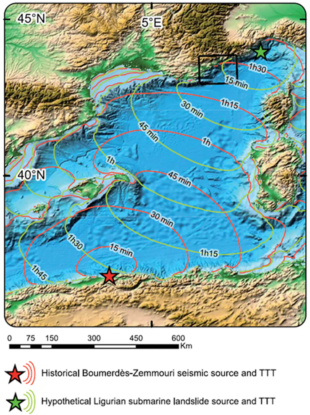
Sahal, Leone & Péroche, 2013, Fourni par l’auteur
An operational warning system for France
France has had a national tsunami alert system that has been part of the Centre d’alerte aux tsunamis (Cenalt) since July 2012, in conjunction with the international system coordinated by UNESCO in the Mediterranean. This system makes it possible to rapidly detect potentially tsunami-generating earthquakes and transmit an alert in less than fifteen minutes to the interdepartmental crisis management operational centre (Cogic) and foreign alert centres.
It is then up to the authorities to disseminate alert messages to the population, in particular via the FR-Alert platform, which allows notifications to be sent to the mobile phones of people located in the danger zone.
However, this global system only covers tsunamis caused by distant earthquakes and is not very effective in the case of local tsunamis or those caused by underwater landslides, where the time it takes for the tsunami to reach the coast may be less than the warning time. This is why it is important to raise awareness among coastal populations about detecting warning signs: felt earthquakes, abnormal sea movements, most often seawater retreats preceding the run-up of the tsunami, but not always.
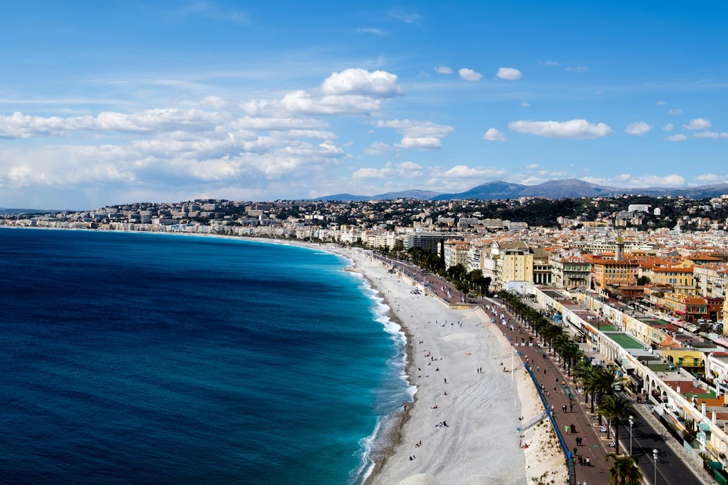
Nice – Côte d’Azur coastline is highly at risk
Along the entire French Mediterranean coastline, an evacuation zone has been defined by government agencies and the University of Montpellier, based on altitude, distance from the sea and historical data. It corresponds to coastal areas with an altitude of less than 5 metres that are less than 200 metres from the sea. Along river mouths, this distance is extended to 500 metres with respect to the estuary.
Including Corsica, 1,700 km of coastline, 187 towns along the French Mediterranean coast, and at least 164,000 residents would be affected. At the height of the summer, an estimated 835,000 beach users would also need to be taken into consideration in the event of a tsunami.
The Nice – Côte d’Azur metropolitan area is vulnerable for a number of reasons: dense urbanisation, strong tourist appeal, and very busy beaches. Our photo analysis and modelling work have enabled us to estimate that tens of thousands of people are present in the area to be evacuated during periods of high visitor numbers (between 10,000 and 87,000 people on the beaches, depending on the season and time of day).
Evacuating ahead of a tsunami: the plan for Nice and surrounding coastal areas
When faced with a tsunami, evacuation is the only effective means of ensuring civilian safety. International experience shows that rapid and well-prepared evacuation procedures can save the vast majority of exposed populations. Reactive evacuation measures, for example, saved 96% of Japanese inhabitants when the major tsunami struck the Tōhoku coast on March 11 2011.
In Nice – Côte d’Azur, a comprehensive evacuation strategy has been developed and supported by scientific research led by the University of Montpellier’s Laboratory of Geography and Planning. It is based on optimised walking routes, taking into account slopes, obstacles, travel speeds and congestion points. Refuge sites located out of “waves’ reach” were identified and validated by local authorities, and evacuation routes were devised using algorithms to find the fastest routes.
In total, nearly a hundred refuge sites have been mapped out and incorporated into operational evacuation plans designed to quickly guide people to safe places.

C. Thomin, MNCA, 2026, Fourni par l’auteur
From science to action: preparing the population
Raising tsunami awareness should go beyond evacuation mapping: safety drills such as evacuation exercises, particularly in schools or gradually introducing public warning signage; contribute to encouraging responsible behaviour. Several initiatives like these have been implemented in Nice via a project with students in Montpellier.
In Nice, a publicly accessible information platform with interactive maps also allows users to find evacuation zones, routes and instructions to follow in the event of an alert. These tools contribute to the development of a genuine tsunami risk culture.

LAGAM/UMPV, 2026, Fourni par l’auteur
Becoming ‘Tsunami Ready’ territory
Beyond France’s Côte d’Azur coastal area, the information portal can be applied to other coastlines elsewhere in France and Europe, both in the Mediterranean and overseas, where tsunami run-up times can be just as short.
The initiatives that are being implemented in Nice are in keeping with UNESCO’s Tsunami Ready international recognition programme (TRRP). This 12-point programme aims to certify territories that are capable of anticipating a tsunami risk, prepare their populations and coordinate an appropriate response.
The first towns to be awarded the label and that have benefited from our team’s scientific and technical support were Deshaies in Guadeloupe and Cannes, with Nice set to join the programme in the near future.
When facing a wave that can arrive in a matter of minutes, being prepared to evacuate undoubtedly makes all the difference.
This article was written with the help of Louis Monnier, Monique Gherardi, Matthieu Péroche and Noé Carles, Université de Montpellier Paul-Valéry.

A weekly e-mail in English featuring expertise from scholars and researchers. It provides an introduction to the diversity of research coming out of the continent and considers some of the key issues facing European countries. Get the newsletter!
![]()
Frédéric Leone ne travaille pas, ne conseille pas, ne possède pas de parts, ne reçoit pas de fonds d’une organisation qui pourrait tirer profit de cet article, et n’a déclaré aucune autre affiliation que son organisme de recherche.
– ref. Tsunami risks in the Mediterranean: why Nice should prepare an evacuation plan – https://theconversation.com/tsunami-risks-in-the-mediterranean-why-nice-should-prepare-an-evacuation-plan-277683