In an interview with NBC News in January 2026, Donald Trump said: “Maga is me. Maga loves everything I do.” Until recently, this statement was true. But over the past several months, cracks have begun to appear in the loyalty of the US president’s “Make America Great Again” base.
Two of the movement’s most prominent figures – former congresswoman Marjorie Taylor Greene and conservative political commentator Tucker Carlson – have voiced their discontent with the leader they previously lavished with unconditional support.
Greene’s falling out with Trump was rooted in her advocacy for releasing the investigative files related to late child sex offender Jeffrey Epstein. But it also centred on her discomfort with US support for Israel and a sense that Trump had abandoned his “America first” campaign promises.
In December 2025, Greene told CNN that “the dam is breaking” on Trump’s grip over the Republican party. As an example, she pointed to the 13 Republicans who voted with Democrats that month to overturn an executive order that allowed Trump to fire federal employees. Greene resigned from the House of Representatives in January.
Carlson’s more recent break with Trump was equally dramatic. “I don’t hate Trump,” he told the Wall Street Journal in an interview released on April 25. “I hate this war [in Iran] and the direction this US government is taking.” Carlson went so far as to apologise to the public for “misleading” them into voting for Trump in 2024.
In a week when an attempt to assassinate Trump is once again headline news, we are reminded of Carlson’s take on a previous attempt on the US president’s life in 2024. Carlson had invoked “divine intervention” to explain Trump’s survival of that attempt, declaring “something bigger is going on here”.
At that point, the president had religious-right elites firmly on his side. This fervour has dissipated in recent times. But are Greene and Carlson representative of a broader problem for the Maga movement, or are they just a pair of high-profile defections and nothing more?
Putting ‘America first’
The grievances and concerns outlined by Greene and Carlson are real. When Trump ran for president in 2016, he broke with Republican orthodoxy by denouncing the Iraq war as a catastrophic mistake. He promised to extract the US from costly foreign wars and put America ahead of global policing commitments.
His first-term record was somewhat mixed, but the key takeaway was that no new major wars were initiated. On the 2024 campaign trail, Trump repeated these earlier pledges. He said he would end the Ukraine war within 24 hours and keep the US out of new conflicts. Trump has clearly reneged on these commitments.
The Iran war is broadly unpopular with the US electorate. Polls show that more people are against the war than support it. On average, 15% more people oppose than back it, and in some recent surveys that gap is even bigger, with up to 27% more people against than in favour. About 75% of US adults also now describe the economy, which is being affected by higher prices, as “very” or “somewhat” poor.
This dissatisfaction is visible among Republicans voters, though probably not to an extent that suggests support for Trump is in danger of imminent collapse. Recent polling by the Associated Press and NORC Center for Public Affairs Research indicates that, while dropping by 13 percentage points compared to a year ago, 38% of Republican voters still “strongly” approve of Trump’s presidency.
At the same time, there are some signs that Trump’s core Maga base remains largely steadfast in its support, despite the very vocal dissent from some. The same poll found that roughly 90% of Americans who self-identify as “Maga Republicans” approve of Trump’s overall job performance. Another survey by NBC suggests that 87% of these people currently approve of his handling of the war in Iran.
While these surveys are unlikely to capture the full range of sentiment within the Maga movement, they still indicate that Trump retains a solid core of support from members of this group. However, if the conflict drags on and economic pain deepens, the room for elite dissatisfaction to percolate down to the base is likely to widen.
Presidential ambitions
There may be other reasons explaining why Carlson, in particular, has broken with Trump. As Jason Zengerle, a journalist at the New Yorker magazine and the author of a biography of Carlson, put it recently when discussing Carlson’s reversal on Trump: “He’s also sort of making a political move.” Various media outlets have suggested that Carlson may be eyeing a 2028 presidential run.
Some commentators, including White House counterterrorism adviser Sebastian Gorka, have drawn parallels between Carlson and Pat Buchanan. In the 1990s, Buchanan challenged President George H.W. Bush over the Gulf war and reshaped the Republican party’s ideological trajectory even without winning its presidential nomination.
Greene has floated Carlson for president. In a social media post in March, she wrote: “I SUPPORT TUCKER. Trump doesn’t even know what Maga is anymore.” Carlson, for his part, has publicly dismissed a presidential bid.
But this rebranding exercise, of attempting to seize the Maga label from Trump and attach it to a new vessel, is a significant development. It suggests that “America first” is no longer exclusively synonymous with one figure.
The looming question is whether this seed of elite discontent can grow into something organisationally meaningful before 2028, when Americans elect their next president.
Clodagh Harrington does not work for, consult, own shares in or receive funding from any company or organisation that would benefit from this article, and has disclosed no relevant affiliations beyond their academic appointment.
Source: The Conversation – UK – By Vikram Niranjan, Assistant Professor in Public Health, School of Medicine, Health Research Institute, University of Limerick
What people see on screen can shape what they do off it. When actors such as James Dean and Marlon Brando lit cigarettes in 1950s rebel films, smoking came to signify cool, defiance and desire for an entire generation.
Among 12- to 17-year-olds in the US, smoking initiation rose from about 20% in the early 1950s to roughly 35% to 40% by the mid-1960s, according to retrospective data from national surveys. Screen media do not simply reflect society. They can also influence how people think about health, risk and behaviour.
Film and television reach vast audiences, embedding health-related behaviours in dramatic storylines. Medical dramas such as Grey’s Anatomy and ER have brought hospital life into living rooms around the world, shaping public ideas about medicine and, for some viewers, even inspiring careers in healthcare.
Sometimes films become accidental public health educators. During the COVID-19 pandemic, the 2011 film Contagion surged in popularity as viewers returned to it for insight into viral spread, quarantine and contact tracing. Its depiction of outbreak control closely mirrored real public health responses, reinforcing messages about handwashing and physical distancing, as described in this report from the Centers for Disease Control and Prevention, the leading US national public health agency. When storytelling aligns with science, entertainment can improve public understanding of health risks.
But screen influence can also be harmful. Bollywood has long shaped popular culture across south Asia, and iconic films in the 1990s and early 2000s often presented smoking and drinking as stylish, casual and glamorous. These portrayals are not trivial. Research suggests that adolescents heavily exposed to tobacco imagery in Indian films are roughly twice as likely to experiment with tobacco as those with lower exposure.
Global evidence shows similar patterns. A systematic review found that adolescents who frequently see smoking in movies are significantly more likely to start smoking themselves. Despite growing awareness of the issue, tobacco imagery remains common: more than half of major box-office films released in 2024 included some form of tobacco depiction. Anti-smoking warnings shown before films can reduce pro-smoking attitudes slightly, but repeated on-screen smoking scenes often have a stronger effect.
Alcohol follows a similar pattern. Teen films often frame drinking as harmless fun while downplaying addiction, injury and long-term health consequences. Studies link heavy exposure to these portrayals with earlier and riskier alcohol use among adolescents. More recently, streaming series have helped make casual vaping seem socially routine, reinforcing the idea that e-cigarettes are acceptable and relatively harmless.
Screen storytelling shapes more than substance use. Hollywood’s beauty ideals, centred on thin bodies, flawless skin and effortless glamour, can distort body image, especially among teenage girls. A striking example occurred in Fiji after western television arrived in the mid-1990s. Within three years, self-induced vomiting to control weight had risen from 0% to 11.3% among adolescent girls, while the proportion showing high levels of disordered eating attitudes rose from 12.7% to 29.2%. In interviews, some girls explicitly linked their interest in weight loss to television characters.
Some portrayals carry even greater risks. Research shows that graphic depictions of suicide in films and television dramas can trigger short-term increases in similar behaviour among vulnerable viewers. These concerns have prompted growing collaboration between mental health experts and entertainment producers to encourage safer storytelling.
Yet screen media can also improve health understanding. The World Health Organization has long supported entertainment-education, in which health messages are woven into dramas and soap operas. In parts of Africa and Asia, television narratives addressing HIV prevention, maternal health and malaria have increased clinic visits, testing uptake and awareness. In Ghana, culturally relevant health films have encouraged women to attend cervical cancer screening and antenatal care.
Some films have also helped shift public attitudes. In 1993, Philadelphia humanised the AIDS epidemic, helping reduce stigma and foster empathy towards people living with HIV. In India, the 2007 film Taare Zameen Par helped destigmatise dyslexia and encouraged schools to take learning difficulties more seriously. Hollywood blockbusters such as Outbreak have heightened awareness about infectious disease threats and preparedness.
Young audiences may be especially responsive to these messages. Children and teenagers spend hours consuming films and streaming content, often absorbing fictional lifestyles as cues about what is normal, attractive or desirable.
Creative media can also support wellbeing in less obvious ways. In my own research exploring online dance sessions for people with pulmonary fibrosis, a chronic lung disease, participants exercised to familiar Hollywood songs and simple choreography. The programme improved mood and engagement while offering modest health benefits, showing that film, music and movement can be harnessed positively.
Film-makers may not think of themselves as health educators, yet their work can shape real-world people’s beliefs and behaviours. A single scene can glamorise smoking or reckless drinking. It can also reduce stigma, encourage people to seek help, or make complex health information easier to understand.
Films are shaped by the societies that produce them, but they shape society in return. The next blockbuster may aim only to entertain. Even so, the story it tells may subtly influence how audiences think about their bodies, their habits and their health.
Vikram Niranjan receives funding from New Foundations, Research Ireland for a research about dance as an exercise.
Source: The Conversation – UK – By Mehreen Ashraf, Lecturer in the Future of Work and Responsible AI, Cardiff Business School, Cardiff University
For many people, the rollout of smart technology across the UK’s road network has been clouded by fears about the removal of traffic-free safety lanes. Traditionally, motorway hard shoulders offered motorists a safe haven into which they could steer stricken vehicles.
But amid growing traffic numbers, the rationale for smart motorways (part of the UK government’s wider digital roads plan) was to free up these extra lanes to traffic. During a breakdown, the remote monitoring system could then quickly reinstate a temporary hard shoulder while the broken down or crashed vehicle was removed.
In 2020, BBC Panorama reported that 38 people had been killed on smart motorways in the preceding five years. Since then, campaign groups have continued to highlight fatal collisions on smart motorway stretches where broken-down vehicles have been struck in live traffic.
In April 2023, the government’s rollout of more smart motorways in England was halted by then-prime minister Rishi Sunak on the grounds of both safety and cost. However, existing smart motorways remain in operation and continue to receive safety upgrades.
The National Highways’ most recent stocktake on smart motorways in England, published in December 2024, stated: “Overall, in terms of deaths or serious injuries, smart motorways remain our safest roads.”
Video: Sky News.
But the same year, another Panorama investigation found nearly 400 instances where safety technology had lost power on smart motorway stretches between June 2022 and February 2024.
As part of a National Highways-funded research programme, I and other researchers at Cardiff University have worked with drivers and transport-sector experts to explore how people feel about the future of the UK’s road network. We investigated their concerns not only around safety but also surveillance and data collection.
Sense of uncertainty
The UK’s digital roads strategy entails much more than smart motorways. Even after the hiatus on building new smart motorways in England, there is still a growing ecosystem of digital and data-driven technologies embedded across the UK road network. These include roadside sensors to monitor traffic flow, cameras to detect incidents and infrastructure that communicates with control centres.
The aim is not automation for its own sake, but earlier detection of problems, faster response, smoother traffic flow and fewer serious incidents. Artificial intelligence and predictive analytics form part of this system.
Our study shows that most people are not resistant to these innovations on the roads. Many people we spoke to welcomed technologies that promise to improve safety or reduce congestion.
However, what unsettled many of them was the sense of uncertainty they felt about the rollout of these systems.
Video: National Highways.
Some participants worried that data generated through digitally connected vehicles and road infrastructure could eventually “be used by insurance companies to penalise drivers”.
Others raised concerns that “systems designed for traffic management might gradually expand into broader forms of surveillance”.
One participant described the possibility of geolocation data revealing patterns of “my daily or weekly movement in the case of a data breach, which is dangerous”.
Another wondered whether automated sensing technologies might distract drivers who feel compelled to “avoid the sensor that records what I am doing”.
In general, people did not reject technological change out of hand. Rather, they want clearer safeguards around how these systems are governed, who can access the data they generate, and how accountability will be maintained as transport infrastructure becomes increasingly “intelligent”. Their concerns centre on questions of fairness, trust and accountability.
Technology trade-offs
Over the past 20 years, smart motorway schemes are estimated to have cost UK taxpayers billions of pounds.
The M4 smart motorway upgrade alone, between junctions 3 and 12, cost around £848 million. Recent safety reviews have committed a further £900 million to retrofit additional emergency refuge areas and improve detection systems on existing stretches.
But the costs are not only financial. There are also social and institutional costs: public confidence, legitimacy and the burden placed on road users to trust systems they did not choose and may not fully understand.
Understanding these trade-offs is important for the public. Smart road infrastructure represents a major public investment to address genuinely risky situations: broken-down vehicles, sudden congestion, poor visibility or secondary accidents caused by delayed response.
Much of this happens invisibly, which is precisely why transparency matters. When people do not understand what systems are doing, silence is easily interpreted as secrecy. Multiple parliamentary and audit reports have raised questions about whether the smart motorway rollout was too rapid, or communication to the public was inadequate – or both.
Some countries have taken a more explicit approach to public engagement around transport innovation. In Sweden, for example, the national road safety strategy, Vision Zero, was introduced as part of a broad public policy framework that placed societal consent and safety at the centre of infrastructure design.
In the UK’s third road investment strategy (2025-2030), smart roads will probably become more interconnected, more predictive and more automated.
Digital twins – virtual models that replicate real roads and infrastructure so planners can test scenarios before implementing them – will play a larger role in planning. Increased data sharing may allow more integrated services across multiple modes of transport. AI and analytics could increasingly support operational decisions.
But the controversy around smart motorways wasn’t just about design choice. It reflects a deeper public concern: what happens when safety depends on systems people can’t see or easily understand?
To answer this, the systems that run smart roads need to be open and trustworthy, safe and reliable in the eyes of those who rely on them every day.
This research was funded by National Highways. The views expressed in this article are those of the author and do not necessarily reflect the views or position of National Highways.
Les particules fines et ultrafines issues du trafic routier sont parmi les polluants les plus nocifs pour la santé. Elles sont aussi les plus difficiles à mesurer à l’échelle d’un quartier. À Paris, un projet de sciences participatives montre comment des citoyennes et des citoyens, en prélevant l’écorce des platanes qui peuplent la ville, peuvent compléter les dispositifs officiels et produire des données utiles à l’action publique.
Dans les grandes villes, la pollution de l’air est surveillée par des stations fixes, par exemple celles d’Airparif en Île-de-France, qui permettent le suivi assez fin de différents types de polluants et de modéliser les tendances générales. Ces stations sont encore trop peu nombreuses pour rendre compte de l’exposition réelle des populations, rue par rue.
Cette limite est particulièrement problématique pour la fraction inorganique des particules fines (de dimensions inférieurs à 2,5 micromètres) et ultrafines (plus petites que 0,1 micromètre). Par « fraction inorganique », on entend les particules minérales ne contenant pas de carbone. Elles sont d’origine soit primaire (érosion des sols, particules métalliques liées à l’usure des plaquettes de frein…), soit secondaire, formées à partir d’autres polluants gazeux. Ces particules sont étroitement liées au trafic routier et associées à des effets sanitaires majeurs. Or, à l’heure actuelle, une seule station de mesure fixe est opérationnelle dans Paris.
Pourtant, la mesure devrait guider l’action : urbanisme, aménagements cyclables, piétonisation ou régulation du trafic reposent sur des données souvent trop parcellaires pour éclairer des décisions locales.
Notre recherche, publiée dans la revue Community Science, s’appuie sur un constat simple : les arbres enregistrent la pollution de leur environnement immédiat. Les particules issues du trafic se déposent sur l’écorce, qui agit comme un capteur passif intégrant la pollution sur plusieurs mois. Cela en fait un indicateur pertinent pour évaluer une exposition chronique.
L’écorce des platanes, révélatrice de pollution
Dans le cadre du projet Ecorc’Air, des volontaires collectent, chaque printemps, au moment de l’exfoliation annuelle, des fragments d’écorce de platanes, arbre omniprésent le long des rues – et notamment au sein de la capitale parisienne, qui abrite plus de 40 000 platanes.
Ces échantillons sont ensuite transmis en laboratoire, où ils sont analysés. La mesure d’une propriété physique particulière de l’échantillon, la susceptibilité magnétique, permet d’estimer la quantité de particules métalliques déposées. Ces dernières sont directement liées aux émissions du trafic automobile.
Sur plusieurs milliers d’échantillons collectés depuis 2016, nous montrons que ce signal magnétique est fortement corrélé à la présence de métaux, dont certains peuvent se révéler toxiques en fonction de leur nature et des doses inhalées. Le protocole mis en place, très accessible même sans connaissances préalables, permet de cartographier la pollution à une échelle très fine, de l’ordre de quelques dizaines de mètres.
Susceptibilité magnétique des échantillons d’écorce collectés au cours des campagnes successives. C. Carvallo et coll., 2024, Fourni par l’auteur
Grâce à cet échantillonnage massif, rendu possible par la participation citoyenne, plusieurs observations ont pu être faites :
d’abord, il existe des « points noirs » persistants. Certaines zones parisiennes présentent des niveaux élevés et récurrents de pollution en particules métalliques depuis le début du suivi : il s’agit des quais à forte circulation (la voie Georges-Pompidou sur sa portion carrossable, par exemple), des abords du périphérique et des axes congestionnés. À l’inverse, les parcs et les espaces éloignés du trafic affichent des niveaux relativement faibles. Ces cartes permettent d’identifier des priorités d’intervention, là où les stations de surveillance classiques ne suffisent pas.
Ensuite, la pollution décroît rapidement avec la distance. Nos données montrent une diminution nette de la contamination en particules dès que l’on s’éloigne de la chaussée, surtout dans les premiers mètres. Cela confirme l’importance du choix de l’implantation des trottoirs et des pistes cyclables vis-à-vis des barrières naturelles (haies ou arbustes) et des zones de repos (espaces où l’on trouve par exemple des bancs).
L’un des résultats les plus frappants concerne l’organisation très concrète de l’espace public. Sur plusieurs grands axes parisiens, notamment le boulevard Saint-Germain, nous avons comparé les niveaux de pollution enregistrés par les arbres selon la configuration de la voie la plus proche : circulation automobile générale (configuration notée A sur le schéma ci-dessous), voie bus-taxi (C), voie partagée bus-vélo-taxi (D) ou présence d’une file de stationnement entre la chaussée et le trottoir (B).
Quatre configurations de la chaussée sont présentes sur le boulevard Saint-Germain. C. Carvallo et coll., 2024, Fourni par l’auteur
Les différences observées sont nettes. Les arbres situés au plus près des voies de circulation automobile présentent systématiquement les valeurs de susceptibilité magnétique les plus élevées. À l’inverse, lorsqu’un élément (haie naturelle, véhicule stationné) sépare la chaussée du trottoir, les niveaux mesurés dans l’écorce sont significativement plus faibles. Cette diminution est suffisamment marquée pour être statistiquement robuste sur l’ensemble des données collectées en 2020 et 2021.
Cette observation suggère que les véhicules en stationnement jouent un double rôle. D’un côté, ils augmentent la distance entre la source d’émission et les piétons et piétonnes et, de l’autre, ils constituent un obstacle physique à la projection directe des particules métalliques issues du trafic vers les trottoirs. Cet effet de « paravent » réduit l’exposition des piétons et piétonnes de manière comparable à celle obtenue en s’éloignant de plusieurs mètres de la chaussée.
Les voies partagées avec les bus et les taxis, souvent présentées comme favorables aux mobilités actives, sont associées à des niveaux élevés de pollution. Ben Welle, CC BY-SA
Notre point n’est pas ici de promouvoir la généralisation de places de stationnement le long des rues, qui favoriserait les déplacements en voiture, mais de pointer l’intérêt de penser une réelle séparation entre la chaussée et les piétons et piétonnes. À l’inverse, les voies partagées avec les bus et les taxis, souvent présentées comme favorables aux mobilités actives, restent associées à des niveaux élevés de pollution particulaire.
Ces résultats, intuitifs en apparence, sont pourtant rarement objectivés par des données à haute résolution spatiale. Ils montrent que des choix d’aménagement très concrets – plans de stationnement, élargissement des trottoirs, séparation réelle des pistes cyclables, séparation spatiale des zones piétonnes et du trafic routier, projets de végétalisation… – ont des effets mesurables sur l’exposition quotidienne des populations.
Un tel niveau de détail n’aurait pas été possible sans la participation massive de volontaires. Les réseaux de surveillance réglementaires, indispensables pour suivre les tendances de fond, reposent sur un nombre limité de stations fixes. À Paris, comme dans la plupart des grandes villes, celles-ci sont trop espacées pour rendre compte des contrastes fins liés à la morphologie des rues, à l’intensité locale du trafic ou aux choix d’aménagement.
Le projet Ecorc’Air repose sur une logique différente : multiplier les points de mesure simples, robustes et comparables dans le temps. En mobilisant des bénévoles pour collecter des échantillons d’écorce de platanes à hauteur de respiration, il a été possible de constituer, année après année, une base de données accessible de plusieurs milliers de points, couvrant des quartiers entiers et permettant des comparaisons temporelles.
Résultats collectés par le projet Ecorc’Air entre 2016 et 2025
Cette approche présente un second avantage souvent sous-estimé : elle transforme la production de données en objet de dialogue. Les lieux de prélèvement ne sont pas ciblés uniquement par les équipes de recherche, mais également par les volontaires et les collectivités, en fonction de leur expertise sur leurs lieux de vie, de leur perception des nuisances, de leurs usages quotidiens ou de leurs questionnements sur des projets urbains en cours. Ce croisement entre savoirs scientifiques et expériences locales enrichit l’interprétation des données et renforce leur légitimité sociale.
Les entretiens menés par l’équipe scientifique dans le cadre du projet montrent d’ailleurs que les motivations à participer sont diverses. Certaines personnes s’engagent par curiosité scientifique, d’autres par inquiétude pour leur cadre de vie ou simple souhait d’amélioration de leur environnement. Du côté des collectivités, l’intérêt tient autant à la production de données environnementales qu’à la capacité à instaurer un lien avec les habitants et habitantes autour d’enjeux environnementaux et sanitaires majeurs. Les sciences participatives ne sont donc pas seulement un outil de mesure : elles deviennent un dispositif d’intermédiation entre science, population et action publique.
Pour les pouvoirs publics, la leçon est claire : il existe aujourd’hui des moyens complémentaires peu coûteux et éprouvés permettant de documenter l’exposition réelle des populations à la pollution liée au trafic. Sans se substituer aux réseaux officiels, ces démarches permettent d’identifier des zones à enjeu, d’évaluer l’impact d’aménagements urbains et de suivre des évolutions dans le temps à une échelle pertinente pour l’action locale.
Les résultats obtenus à Paris montrent que certaines zones restent durablement exposées, malgré une baisse globale des concentrations mesurées à l’échelle de la ville. Ils suggèrent également que des choix d’aménagement apparemment secondaires – emplacement des pistes cyclables, organisation du stationnement, largeur des trottoirs… – peuvent avoir des effets significatifs pour ce qui est de l’exposition aux particules inorganiques des passants et passantes.
Dans un contexte où les recommandations sanitaires internationales sont de plus en plus strictes et où la demande sociale de transparence environnementale s’accroît, ces données fines constituent un appui précieux à la décision. Elles permettent de dépasser les débats trop généraux sur la pollution pour entrer dans une logique d’action ciblée concrète, territorialisée et discutée, en concertation avec les usagers et usagères.
À terme, l’enjeu n’est pas seulement de mieux mesurer, mais de mieux décider. Les sciences participatives, intégrées aux politiques publiques, peuvent contribuer à combler un angle mort majeur de la gouvernance environnementale : celui de l’exposition quotidienne, réelle, vécue, à l’échelle de la rue. À Paris, mais aussi dans d’autres villes européennes, l’intérêt pour ce type de démarches grandit. L’enjeu n’est plus seulement de mesurer, mais de transformer ces données en leviers d’action, à l’échelle des quartiers.
Sivry Yann a reçu des financements de l’Agence Nationale pour la Recherche, du CNRS et de la Fondation Université Paris Cité.
Aude Isambert a reçu des financements du CPT (Centre des Politiques de la Terre) de l’Université Paris Cité (StratEx-IdEx).
Claire Carvallo a reçu des financements du CNRS.
Laure Turcati a reçu des financements à travers le réseau Science Ensemble du label SAPS de Sorbonne Université et de l’Etat au titre de France 2030 dans le cadre du projet SOUND porté par l’Alliance Sorbonne Université.
Christine Franke ne travaille pas, ne conseille pas, ne possède pas de parts, ne reçoit pas de fonds d’une organisation qui pourrait tirer profit de cet article, et n’a déclaré aucune autre affiliation que son organisme de recherche.
Source: The Conversation – USA – By Anne Toomey McKenna, Affiliated Faculty Member, Institute for Computational and Data Sciences, Penn State
Police got cellphone data for many people who happened to be in this area near the time of a bank robbery.AP Photo/Steve Helber
Google tracks the vast majority of cellphones in the United States, collecting your location, usage and device data through installed software and apps. The tracking occurs by various autonomous processes you cannot see or stop, even when you turn off location history, and Google and other companies keep that data for years. Outside of your control and wherever you go, your cellphone continuously creates a durable and revealing digital trail, and law enforcement agencies can get warrants to obtain it.
But some of those warrants aren’t looking for data about a specific person. Instead, police are compelling tech companies to reveal every cellphone in a particular area during certain time periods. Called geofence warrants, their use is at the heart of a case before the U.S. Supreme Court that will determine what the Fourth Amendment’s protections against unreasonable search and seizure mean in the digital age.
The Supreme Court caseChatrie v. United States involves the hunt for a suspect in an armed bank robbery in busy Midlothian, Virginia, in May 2019, and how police settled on a man named Okello Chatrie as the perpetrator.
Detective Joshua Hylton was granted a geofence warrant that compelled Google to search its database and identify every cellphone in a 17½-acre area around the bank, including private residences and a church, for a period of two hours. Working closely with Google, police ultimately narrowed in on Chatrie. When the trial court denied Chatrie’s motion to suppress the geofence-derived evidence, Chatrie appealed.
The Supreme Court will decide if, when and how law enforcement can use geofences. It matters because all cellphone-carrying people can end up in tomorrow’s geofence, like all those who were unknowingly grabbed in the Chatrie search. And nearly all users are unaware of these fences. No one specifically consents to be included in them, but people have no choice. What happened in the Chatrie case is a feat otherwise impossible but for advances in location tracking technology and advanced AI systems.
As a privacy, electronic surveillance and tech law attorney, author and legal educator, I have spent years researching, writing, educating and advising about these kinds of privacy and legal issues, and my books on electronic surveillance and evidence are routinely cited and relied upon by courts grappling with these issues.
A customer walks out of a credit union in Virginia where a robbery in 2019 set in motion events that led to a Supreme Court case. AP Photo/Steve Helber
How geofences work
Geofences are part of modern life. By carrying your smartphone and other devices, you generate location and other device activity data. That data is collected, stored, analyzed, and bought and sold by multiple companies. The location history data being collected about you is what makes geofences possible, and it is comprehensive and precise.
Location history relies on a variety of sources of data that can include cell tower location, cellphone data such as connections to Wi-Fi networks and Bluetooth sources, and cellular data sent via cell tower. This means the communications you received and sent and the apps you used can be swept up in a geofence.
Advanced AI technologies analyze that data to discern increasing amounts of personal and behavioral data – insights about people, groups and activities – that can be used for a variety of purposes, including targeted advertising. Your rich location history and device data get snatched up regularly in such fences by private companies; your present and past self travels through them constantly.
A geofence can be in real time, for instance to identify and track who is at a protest, or any period in the past decade or so. It can be dynamically generated, like a circle around a specific location, or it could be a predefined set of boundaries, such as a specific address or area defined by streets or other geographical boundaries. One geofence warrant that Google received covered 2.5 square miles of San Francisco for a period of 2½ days.
There has been a significant increase in law enforcement’s use of geofence warrants over the past decade. Google revealed in court that it received a 1,500% percent increase in geofence requests from 2017 to 2018, a 500% percent increase from 2018 to 2019, and by 2020, it had 11,500 geofence warrants in a year. Between 2021 and 2023, geofence warrants made up over 25% of all warrants that Google received from law enforcement agencies in the United States.
If you carry a smartphone around with you, Google and other tech companies keep track of where you are and everywhere you’ve been. Dilara Irem Sancar/Anadolu via Getty Images
Search warrants and the Fourth Amendment
The Fourth Amendment is the foundation on which all U.S. electronic privacy laws rest. When government agents want to search or seize a person, place or thing – absent consent or emergency – the Fourth Amendment requires agents to obtain a court-approved warrant based on probable cause. Agents do this by providing a judge with enough evidence to establish probable cause that the person, place or thing to be searched or seized is associated with a crime.
The resulting warrant must describe with “particularity” the specific person, place or thing to be searched or seized. If these requirements are not met, the search is unreasonable and therefore unlawful, and evidence obtained in that search cannot be used in court, barring a good-faith exception.
The Fourth Amendment’s “particularity” requirement strictly forbids general warrants, historically used by British troops against Colonists to engage in overly broad or all-encompassing searches.
Reverse warrants
The only “particularity” that police can specify in applying for a geofence warrant is that a crime occurred at a particular time and place. Hence, geofence warrants are often called reverse warrants because they literally reverse the traditional process of conducting an investigation to identify a suspect and then obtain a warrant to gather information on that suspect. Geofence warrants gather all devices in a time and place, and then, aided by technology, police sift through for potential suspects.
The execution of a geofence warrant is very different from that of a typical warrant. Litigation records reveal a collaborative effort between law enforcement and Google that follows a three-step process. First, law enforcement officials specify in the warrant a time and place to be searched. The data they’re seeking is not merely a list of cellphone devices in the area; it is usually more detailed. For instance, it could include data about whether a device accessed a particular email account or app or sent a text at the time it was in the area of the geofence.
Second, the company provides the officials with an anonymized list of users or devices matching the warrant’s criteria. At this point, things start to become more fluid, and the officials may seek additional information about specific users outside of the initial search parameters.
Third, law enforcement officials then analyze the information and request that the company “unmask” certain users. In complying, Google may tell police the account holder’s name, their address, their email address, and even whether they were communicating or using certain apps during the relevant time. The officials then decide whether any of the users may be connected to the crime.
This close work between the private entity – usually Google – and law enforcement throughout the geofence warrant process raises significant privacy and civil liberties concerns. It also does not appear that there is any court review or judicial oversight during this give-and-take between law enforcement officers and Google in the geofence warrant process.
A split among appeals courts
In the Chatrie case, the trial court took issue with the geofence warrant police used, finding that it lacked particularized probable cause. But the trial court also determined that the officers in question had relied on the defective warrant in good faith, and thus it ruled the geofence evidence could be used against the defendant.
On appeal to the 4th U.S. Circuit Court of Appeals, a divided panel affirmed the trial court’s decision, and it concluded, over vigorous dissent, that obtaining the geofence data was not a search. The full 4th Circuit affirmed the trial court’s decision.
But the 4th Circuit’s 2024 Chatrie decision stands at odds with the 5th Circuit’s 2024 decision in United States v. Smith. In the Smith case, the 5th Circuit ruled that “geofence warrants are modern-day general warrants and are unconstitutional under the Fourth Amendment.” This split among the federal appeals courts should be resolved by the Supreme Court in its Chatrie decision.
Chatrie and the Supreme Court
For decades, the court has grappled with law enforcement’s use of technologies to track the location of people or things, issuing decisions about cell site location information and GPS. It has ruled that the U.S. Constitution requires law enforcement agents to obtain a warrant to track a person using their cellphone location history data or GPS, barring exigent circumstances.
The government is arguing in the Chatrie case that users voluntarily consented to the collection of location history, so they have no reasonable expectation of privacy in the data, and thus there is no violation of the Fourth Amendment.
Questions from the Supreme Court justices during oral arguments on April 27, 2026, indicate that at least some of them consider geofence warrants to be general warrants and thus unconstitutional. But for now, we wait.
Anne Toomey McKenna serves on the Advisory Board to the Institute for Electrical and Electronics Engineers (IEEE)-USA’s Artificial Intelligence Policy Committee (AIPC) and Chairs multiple AIPC subcommittees. The AIPC work involves subject matter and education-related interaction with U.S. Senate and House congressional staffers and the Congressional AI Caucus. McKenna has received funding from the National Security Agency for the development of legal educational materials about cyberlaw (a course which the government still makes available online for the public) and funding from The National Police Foundation together with the U.S. Department of Justice-COPS division for legal analysis regarding the use of drones in domestic policing.
President Lyndon Johnson hands a pen to civil rights leader Rev. Martin Luther King Jr. during the signing of the Voting Rights Act in Washington, D.C., on Aug. 6, 1965. Hulton Archive, Washington Bureau/Getty Images
In a major ruling that would permit weakening the voting power of minorities in the United States, the Supreme Court on April 29, 2026, struck down a Black-majority district in Louisiana’s congressional map as “an unconstitutional gerrymander” and altered the court’s interpretation of the Voting Rights Act.
In a 6-3 decision, the court’s conservative majority argued that Louisiana had violated the law by drawing a second Black-majority district. Justice Samuel Alito wrote that the court was upholding a key part of the Voting Rights Act known as Section 2, which prohibits “voting practices or procedures that discriminate on the basis of race, color, or membership in one of the language minority groups identified” in the act.
But the conservative justices also devised a new interpretation for its application based on historical developments. By doing that, the court majority made it more difficult for plaintiffs to challenge redistricting plans under the act.
Kagan, joined by the other two liberal justices, argued that the decision will make it effectively impossible to use race in redistricting – as has been done historically under the Voting Rights Act – and more difficult to prove discrimination under the act. She wrote, “The court’s decision will set back the foundational right Congress granted of racial equality in electoral opportunity.”
I’m a scholar of national political institutions, election law and democratic representation. The timing of the case carries major implications for the 2026 midterm elections. The decision, by weakening the Voting Rights Act, could make it easier for states to draw partisan gerrymanders of their congressional districts that reduce the power of minorities.
Long legal battle
The central question in the case was to what extent race can, or must, be used when congressional districts are redrawn.
In short, the plaintiffs argued that the state of Louisiana’s use of race to make a second Black-majority district was forbidden by the U.S. Constitution. From my perspective as a scholar of U.S. federal courts and electoral systems, this case represent the collision of decades of Supreme Court decisions on race, redistricting and the Voting Rights Act.
To understand the stakes of the current case, it’s important to know what the Voting Rights Act does. Initially passed in 1965, the act helped end decades of racially discriminatory voting laws by providing federal enforcement of voting rights.
Section 2 of the Voting Rights Act forbids discrimination by states in relation to voting rights and has been used for decades to challenge redistricting plans.
Callais had its roots in the redistricting of Louisiana’s congressional districts following the 2020 Census. States are required to redraw districts each decade based on new population data. Louisiana lawmakers redrew the state’s six congressional districts without major changes in 2022.
State troopers in Selma, Ala., swing billy clubs on March 7, 1965, to break up a march by advocates for Black Americans’ voting rights. AP Photo, File
Soon after the state redistricted, a group of Black voters challenged the map in federal court as a violation of the Voting Rights Act. The plaintiffs argued that the new map was discriminatory because the voting power of Black citizens in the state was being illegally diluted. The state’s population was 31% Black, but only one of the six districts featured a majority-Black population.
Federal courts in 2022 sided with the plaintiffs’ claim that the plan did violate the Voting Rights Act and ordered the state legislature to redraw the congressional plan with a second Black-majority district.
The judges relied on an interpretation of Section 2 of the Voting Rights Act from a 1986 Supreme Court decision in the case known as Thornburg v. Gingles. Under this interpretation, Section 2’s nondiscrimination requirement means that congressional districts must be drawn in a way that allows large, politically cohesive and compact racial minorities to be able to elect representatives of their choice.
Following the court order, the Louisiana state legislature passed Senate Bill 8 in January 2024, redrawing the congressional map and creating two districts where Black voters composed a substantial portion of the electorate in compliance with the Gingles ruling. This map was used in the 2024 congressional election and both Black-majority districts elected Democrats, while the other four districts elected Republicans.
These new congressional districts from Senate Bill 8 were challenged by a group of white voters in 2024 in a set of cases that became Louisiana v. Callais.
Essentially, the plaintiffs claimed that the courts’ interpretation of Section 2 of the Voting Rights Act was unconstitutional and that the use of race to create a majority-minority district is itself discriminatory. Similar arguments about the 14th Amendment’s equal protection clause were also the basis of the Supreme Court’s recent decisions striking down race-based affirmative action in college admissions.
In 2024, a three-judge district court sided with the white plaintiffs in Louisiana v. Callais, with a 2-1 decision. The Black plaintiffs from the original case and the state of Louisiana appealed the case to the Supreme Court. The court originally heard the case at the end of the 2024-2025 term before ordering the case reargued for 2025-2026.
The court’s opinion reinterprets key precedent on the Voting Rights Act and the application of Section 2 to redistricting. It carries major consequences for the federal courts, gerrymandering and the voting rights of individuals.
For 39 years, Section 2 of the Voting Rights Act has required redistricting institutions to consider racial and ethnic minority representation when devising congressional districts. Majority-minority districting is required when a state has large, compact and cohesive minority communities. Historically, some states have redistricted minority communities in ways that dilute their voting power, such as “cracking” a community into multiple districts where they compose a small percentage of the electorate.
Section 2 also provided voters and residents with a legal tool that has been used to challenge districts as discriminatory. Many voters and groups have used Section 2 successfully to challenge redistricting plans.
Section 2 has been the main legal tool for challenging racial discrimination in redistricting for the past decade. In 2013, the Supreme Court effectively ended the other major component of the Voting Rights Act, the preclearance provision, which required certain states to have changes to their elections laws approved by the federal government, including redistricting.
In this case the court did not fully overrule the previous interpretation of Section 2, but it has altered its application. The effect is that it limits the legality of using race in redistricting and the most common way to challenge discriminatory redistricting.
Additionally, because of the strong relationship between many minority communities and the Democratic party, the court’s decision has major implications for partisan control of the House of Representatives.
By changing the interpretation of Section 2, Republicans could use the ruling to redraw congressional districts across the country to benefit their party. Politico reported that Democrats could lose as many as 19 House seats if the Supreme Court sided with the lower court.
This case builds directly on a recent case also authored by Alito. In 2024, the court overruled a lower court’s finding of racial vote dilution in South Carolina.
Sam D. Hayes does not work for, consult, own shares in or receive funding from any company or organization that would benefit from this article, and has disclosed no relevant affiliations beyond their academic appointment.
Depuis le 2 mars, le Congrès avait soixante jours pour avaliser l’intervention contre l’Iran. Le délai expire ce 1er mai, et la guerre n’a toujours pas été autorisée. Donald Trump ne va sans doute pas rappeler ses militaires pour autant. Mais les élus démocrates, hostiles à ce conflit, pourraient bientôt voir une partie de leurs collègues républicains leur prêter main-forte pour tenter d’imposer la cessation d’une opération très impopulaire.
Si Donald Trump ne met pas fin à la confrontation militaire de son pays avec l’Iran dans les tout prochains jours, il enfreindra la loi des États-Unis.
La loi sur les pouvoirs de guerre (War Powers Resolution) adoptée en 1973 stipule qu’un président américain ne peut pas conduire une guerre sans l’aval du Congrès pendant plus de soixante jours. Passé ce délai, soit le Congrès doit déclarer la guerre et donc l’autoriser officiellement, soit le commandant en chef est constitutionnellement tenu de cesser les hostilités.
Même si un cessez-le-feu précaire prévaut actuellement entre Washington et Téhéran, le texte s’appliquerait en tout état de cause aux navires chargés de maintenir le blocus américain des ports iraniens.
Ce vendredi 1er mai, soixante jours se seront écoulés depuis le lancement de l’opération Epic Fury le 28 février dernier. Que signifie le dépassement de ce délai légal ?
Qu’est-ce que la loi sur les pouvoirs de guerre ?
Adoptée en novembre 1973 par le Congrès — une majorité des deux tiers a pu surmonter le veto opposé par le président Richard Nixon —, la loi sur les pouvoirs de guerre visait à mettre fin à l’usurpation récurrente, par les présidents des États-Unis, de la prérogative de déclarer la guerre, qui revient constitutionnellement au Congrès. Le texte a été adopté dans un contexte marqué par le départ du contingent américain du Vietnam à l’issue de plusieurs années d’une guerre que le Congrès n’avait jamais officiellement autorisée.
Plus de cinquante ans plus tard, force est de constater que cette loi n’a pratiquement jamais été réellement appliquée. Comprenant plusieurs formulations juridiques imprécises, le texte admet de nombreuses exceptions et ouvre la voie à de multiples interprétations différentes. Au cours des décennies, les présidents successifs et leurs conseillers se sont engouffrés dans ces brèches.
Ainsi, depuis Nixon, aucun président n’a véritablement été contraint par l’existence de la loi. Ceux qui ont déclenché des opérations sans feu vert du Congrès (Reagan en Grenade en 1983 ; George Bush père au Panama et en Yougoslavie en 1999 ; Biden au Yémen en 2023 ; puis Trump au Venezuela et en Iran en 2026, NDLR) se sont contentés de l’évoquer du bout des lèvres sans jamais réellement se mettre en conformité avec son esprit.
Le Congrès lui-même porte une porte de responsabilité de cet échec, lui qui a souvent renoncé à exercer ses prérogatives constitutionnelles en matière de déclaration de guerre. Pour autant, dans le conflit actuel, la loi pourrait bien être réactivée, avant tout parce qu’elle offre aux élus républicains hostiles à ce conflit un moyen de tenter de mettre fin à une guerre devenue impopulaire.
Que dit la loi ?
L’article 4 impose au président de présenter un rapport au Congrès dans les quarante-huit heures suivant l’engagement des troupes américaines dans des « hostilités ». Ce document doit détailler le fondement constitutionnel et législatif sur lequel repose l’action, sa justification, ainsi que l’ampleur et la durée prévues de l’intervention américaine.
La présentation de ce rapport déclenche alors un délai de soixante jours prévu par l’article 5. Si, à l’expiration de ce délai, le Congrès n’a pas déclaré ou autorisé la guerre — ou prolongé le délai —, le président doit impérativement mettre fin à l’action militaire.
Du fait du caractère automatique de cette disposition, les législateurs n’ont rien à faire pour la déclencher. Ils n’ont donc pas à se prononcer publiquement contre la politique militaire et de sécurité nationale conduite par le président.
Donald Trump a soumis son rapport sur la guerre avec l’Iran le 2 mars ; le compte à rebours de 60 jours expire donc le 1er mai.
Jusqu’à présent, le Congrès n’a toujours pas déclaré la guerre, bien que les républicains aient bloqué de nombreuses initiatives législatives des démocrates visant à mettre fin à la guerre ou à limiter la capacité de Trump à agir sans l’accord du Congrès. Ce dernier a également la possibilité de prolonger le délai de 60 jours pour une durée maximale de 30 jours, ce qui nécessiterait un vote à la Chambre des représentants et au Sénat.
Des républicains de plus en plus mal à l’aise
Ce qui distingue fondamentalement cette guerre contre l’Iran des autres conflits menés par les récents présidents américains, c’est son impopularité. 34 % seulement des Américains la soutiennent, selon un sondage Reuters-Ipsos publié cette semaine.
On n’a observé aucun « effet de ralliement autour du drapeau » depuis le déclenchement d’Epic Fury. Les élus du Congrès, très sensibles à l’opinion de leurs électeurs, n’hésitent pas à s’opposer à Trump sur cette question. Beaucoup s’exposeraient à un retour de bâton électoral s’ils affichaient publiquement leur soutien à la guerre.
Exemple parmi d’autres : le sénateur républicain de l’Utah John Curtis a publié un article dans lequel il déclare qu’il ne soutiendra pas la guerre si le délai de 60 jours expire sans l’accord du Congrès. D’autres républicains ont fait écho à cette position.
Que se passera-t-il si Trump ignore la date butoir ?
Compte tenu de son mépris général pour la Constitution et le droit écrit, Donald Trump ignorera très probablement l’obligation légale de mettre fin à la guerre. Il pourrait, comme Nixon en 1973, arguer que la loi sur les pouvoirs de guerre est inconstitutionnelle, et cherchera sûrement à la contester devant les tribunaux.
Tout dépendra alors de la réaction du Congrès. Les démocrates envisageraient d’intenter une action en justice contre l’administration, bien que de tels recours se soient jusqu’ici révélés d’une efficacité limitée.
Le président pourrait également faire valoir que la « loi ne s’applique pas », car les forces américaines ne sont actuellement pas engagées dans des hostilités directes en Iran — un argumentaire déjà employé par Barack Obama lorsque le délai de 60 jours avait expiré lors des opérations militaires américaines en Libye en 2011.
Le 2 mars, quand Trump a adressé une notification officielle au Congrès, il a tenu à préciser qu’il agissait en vertu de son « autorité constitutionnelle en tant que commandant en chef et chef de l’exécutif » — mais aucune de ces deux fonctions ne lui confère le pouvoir d’engager les États-Unis dans une guerre sans l’approbation du Congrès. Il n’a d’ailleurs pas évoqué la loi sur les pouvoirs de guerre, se contentant de déclarer que son rapport était « conforme » à celle-ci — une formulation standard utilisée par ses prédécesseurs, qui ont tous fait preuve d’une certaine réticence à respecter ses dispositions.
Par le passé, lorsque les présidents et le Congrès se sont affrontés au sujet de la loi sur les pouvoirs de guerre, ils sont généralement parvenus à un compromis au cas par cas, souvent favorables au président. Mais cette fois-ci, la donne pourrait changer. Trump gère mal une guerre impopulaire, avec des majorités très fragiles au Sénat (53 républicains et 45 démocrates) et à la Chambre des représentants (218-212), à six mois des élections de mi-mandat.
Si rien ne change d’ici le 1er mai, la loi de 1973 pourrait connaître son heure de gloire en devenant, pour la première fois depuis son apparition, un véritable instrument de confrontation entre les pouvoirs exécutif et législatif.
John Hart ne travaille pas, ne conseille pas, ne possède pas de parts, ne reçoit pas de fonds d’une organisation qui pourrait tirer profit de cet article, et n’a déclaré aucune autre affiliation que son organisme de recherche.
Rock paintings are found throughout Zimbabwe. They were made during the last 10,000 years by hunter gatherer groups and later by farming communities.
These came to the attention of the ERC Artsoundscapes project, based in Spain, in 2021. The project brings together experts in archaeology, ethnography, psychology and acoustic engineering to explore how humans understood sound in prehistoric times. Our team has studied some of the rock art of South Africa in which dance scenes are depicted, and we have begun work on documenting and analysing similar rock art in Zimbabwe.
Zimbabwe’s rock paintings are concentrated in the country’s eastern provinces, which is where we’ve focused so far. More can be found in the Matobo World Heritage Cultural Landscape in Matabeleland South, which will be the focus of future study.
We have published an article describing dance scenes in this rock art and comparing them with information from ethnographic sources to understand what kinds of dances they depict. The ethnographic research was done by anthropologists and focused on hunter gatherer groups in the broader southern African region (Botswana and Namibia).
We found that all the kinds of dances that have been described in living cultures – dances for ritual, entertainment or special circumstances – are depicted in Zimbabwe’s rock art. But ritual is a central theme.
This points to the need to refine our classification of rock art scenes. We’ve been using features like the body posture of depicted figures to classify a scene as a dance. But ritual dances often involve going into a trance state – and this alters a person’s ability to control their body, move in synchrony with other people and follow “rules” of a dance. Therefore, it may be necessary to reconsider whether some rock art scenes in Zimbabwe, and in the whole of southern Africa, depict dances or not.
Here we will discuss some examples of the rock art in Zimbabwe and explain how we categorised them.
Analytical method
We reviewed published works by archaeology researchers such as the late Peter Garlake and university professor Ancila Nhamo. We also used online resources, including the British Museum online collection by rock art photographer and author David Coulson, which features rock art from Zimbabwe and other southern African countries.
Our inquiry aimed to determine whether all dances that have been recognised ethnographically, in living people, in Zimbabwe as well as in other countries of southern Africa, are also represented in Zimbabwe’s rock art.
We analysed the scenes by applying six attributes that have proved useful in studies in other parts of the world, such as the Middle East and the western Mediterranean. The attributes are divided into those related to the dancers themselves and those related to the type of dance. They are:
dancers’ body posture (including bent figures, outstretched arms and flexed legs)
items they hold, such as sticks, rattles, or headgear
interaction between dancers
evidence of synchrony
direction of movement
gender of the figures represented.
Dance scenes in Zimbabwe rock art
Using these attributes, we can say that a scene such as this one found at Lake Chivero is a dance because it has several men all wearing aprons, displaying the same body posture, and positioned in synchrony with outstretched arms.
Yet, in other scenes we encountered unexpected problems with the second group of attributes (type of dance). Those were designed to analyse dance scenes in other parts of the world with different belief systems. But they are not always valid when dancers engage in trance dances.
One example of this type of scene that does not follow the norm is found at a site called Chivhu. A series of therianthropes (figures with both human and animal features) were painted associated with a large snake bearing two animal heads. In the scene we analysed there, the interaction between dancers is irregular, their movements are not synchronised, and the direction of the dance is not homogeneous, as would be expected in a regular dance. But regular interaction, synchronisation and uniform direction are simply not possible when dancers are in an altered state of consciousness. So, this scene might not look like a dance but it probably is one, based on what we know from studies of living people in cultures associated with the makers of the rock art.
Other dances recognised ethnographically as being of ritual character are initiation dances. An example of a dancing scene which may indicate a boys’ initiation dance can be found at a rocky outcrop in Glen Norah, Harare. American anthropologist Lorna Marshall, who undertook fieldwork among the !Kung people of the Kalahari Desert in the 1950s, 1960s and 1970s, described how the !Kung boys from Nyae Nyae in Namibia in the 1950s sometimes bent their upper bodies into an almost right-angle posture while dancing. The dancers in the painted scene are accompanied by other men who are not participating in the dance. These kinds of initiation dances are not documented or practised in Zimbabwe, however. So although the painted scene looks like an initiation dance, it probably isn’t one.
Rock art may also depict eland dances, the girls’ initiation dance. For example, dancing scenes depicting only women that may be interpreted as eland dances are found in Chipinge and Mudadi in Zimbabwe’s Chivi district.
The Makonde dance from Mashonaland West, which features more than 30 performers, is not easy to interpret. It is not clear whether this represents a large dance scene or if the dancers can be divided into different groups. Some individuals are clapping, while others are dancing, which may indicate the presence of trance dancers (group labelled b). Additionally, there are female dancers with tufts on their legs and wearing back aprons (group labelled a). These could be dancing for entertainment, because in reality for an eland dance (a ritual) they would probably remove the aprons.
Categorising certain dances can be challenging, and some may have been performed purely for entertainment purposes. For example, there is a dancing scene at Charewa that depicts women, men, and possibly children participating. We propose that this could represent an entertainment dance or a dance in some particular circumstance where everyone joined in.
Charewa site, Dance Scene 1. Garlake 1987a, Fig. 10, Fourni par l’auteur
Other elements emerging from the analysis of the dance scenes found in Zimbabwean rock art include the presence of musical instruments and a variety of artefacts associated with the dancers. Hand rattles frequently appear in dancing scenes and have been recognised as the most depicted musical instruments in Zimbabwean rock art, as we’ve discussed in an article about musical instrument representations.
Dancers are sometimes depicted with dancing sticks or other accessories, not only rattles. For instance, some figures appear to be holding round discs that are difficult to identify at Chikupu.
Moreover, dancers may be adorned with beads, as observed at Charewa Panel 2, and often wear distinctive headgear, typically resembling antennae, which may symbolise feathers as described in ethnographic accounts.
It’s important to accurately identify and describe these scenes. Our analysis highlights the valuable information that can be gleaned from close examination of the depictions, as well as from the use of ethnohistorical sources related to dance.
Margarita Díaz-Andreu received funding from the European Research Council (ERC) under the European Union’s Horizon 2020 research and innovation programme for the ERC Artsoundscapes project (Grant Agreement No. 787842) . Margarita Díaz-Andreu is affiliated with ICREA and the University of Barcelona.
Joshua Kumbani does not work for, consult, own shares in or receive funding from any company or organisation that would benefit from this article, and has disclosed no relevant affiliations beyond their academic appointment.


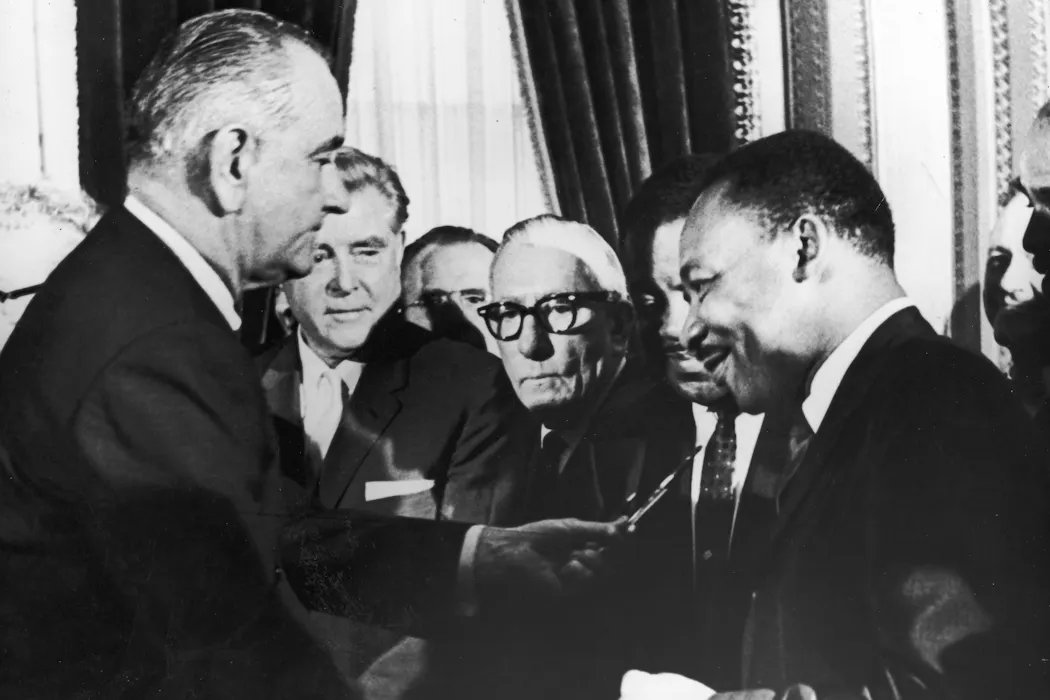


