Listening to nonhumans: What music can teach about humanity’s relationships with nature and the divine

Source: The Conversation – USA (3) – By Jeffers Engelhardt, Professor of Music, Amherst College

Members of the Alevi Muslim community perform a ritual semah dance during celebrations for Norooz, or the Persian New Year, in Berlin. Adam Berry/Getty Images

As someone who teaches and researches music and religion, I’ve always been curious about inspiration and how it connects humans to other beings.

Musicians can be inspired by great artists, living and dead; by technologies that expand their experience, like artist Brian House’s macrophones that capture low-frequency infrasound; by plants and animals; and by the unseen, unheard presence of the supernatural. After all, the word inspiration is rooted in the Latin for “breathing in.” Often, it was associated with spiritual or divine influence – inspiration coming from other realms.

In my research and teaching, recognizing non-human beings is ethically important and an act of intellectual humility. It ensures that I honor other people’s religious and musical experiences, and it admits that we cannot know precisely what they know. One person’s reality may not translate to our own understanding.

That’s what led me to design this course: “Music, Sound and Research with Non-Humans.”

What does the course explore?

The “with” in the course title is key: I want students to learn about how human knowledge exists in relationship with non-humans. To do this, we read and listen widely.

In research using Actor-Network Theory, for example, relationships between humans and non-humans are central: musicians, scientists and their instruments; you and your smartphone; humans and gods. In each case, humans and non-humans are both considered actors – beings that make a real difference in the world.

Music scholar Peter McMurray uses a similar lens in his work on Alevi “semah” ritual, which involves music, movement and poetry. Alevism is a mystical tradition of Islam in Turkey that has long faced discrimination. Some of the sung poetry used for semah is inspired by sacred animals, such as cranes. In semah, participants experience cranelike flight through music and dance, which are central to Alevi ritual.

Dance is an important part of Alevi semah.

Or consider traditions of chanting revealed in texts like the Quran, which means “recitation” in Arabic. Spiritually, the purpose is not only to learn the scripture, but to draw closer to its sonic essence. Recitation recalls moments of encounter between humans and the divine, most important being the Prophet Muhammad receiving the Quran through the Angel Gabriel.

We also look beyond music, to everything from medicine and biology to economics, to study relationships between humans and non-humans. One of our favorite readings, for example, is “The Mushroom at the End of the World” by anthropologist Anna Lowenhaupt Tsing. This is a rich ethnographic account of the relationships between humans and matsutake mushrooms, which are highly prized in Japanese cuisine: the piney forests where matsutake grow, the human activities that make them thrive, the foragers who collect them, and the global markets where they are traded.

My students Luana Espinoza and Sofia Ahmed Seid describe our course as exploring a kind of symbiosis: the word biologists use to describe close, often mutually beneficial, relationships between species.

What’s a critical lesson from the course?

This course readies students to confront serious, challenging forms of intellectual diversity, considering how the possibilities of different truths and paradigms might inform their research.

Both students this semester are science majors working on senior theses: Espinoza in chemistry and Seid in neuroscience. By reading and listening to others’ accounts of human and non-human relationships, they say they no longer feel required to leave an essential part of themselves at the classroom door.

Music and sound bridge the physical and metaphysical, the natural and the supernatural. Because of this, they are invaluable for encountering complex truths.

Amherst College students Sofia Ahmed Seid and Luana Espinoza contributed to the preparation of this article.

Uncommon Courses is an occasional series from The Conversation U.S. highlighting unconventional approaches to teaching.

The Conversation

Jeffers Engelhardt does not work for, consult, own shares in or receive funding from any company or organization that would benefit from this article, and has disclosed no relevant affiliations beyond their academic appointment.

ref. Listening to nonhumans: What music can teach about humanity’s relationships with nature and the divine – https://theconversation.com/listening-to-nonhumans-what-music-can-teach-about-humanitys-relationships-with-nature-and-the-divine-256840

Most Pennsylvania voters ignore judicial elections − a political scientist explains why they matter, especially in a battleground state

Source: The Conversation – USA – By Daniel J. Mallinson, Associate Professor of Public Policy and Administration, Penn State

Three of the seven judges on PA’s state supreme court are up for retention votes in November 2025. AP Photo/Matt Rourke

This November, there will be no candidate for president, governor, senator or even representative on the Pennsylvania ballot.

Pennsylvanians will vote, however, on three members of their seven-member state Supreme Court.

These are retention elections, which means that voters will decide whether to keep the current members of the court or remove them.

The three seats up for grabs are three of the five Democrats that hold the majority on the court. They are Justices Christine Donohue, Kevin Dougherty and David Wecht.

While the typical voter may not think much about judicial elections, political operatives and political scientists, like me, know they have consequences.

I think it’s important that voters understand what a retention election is and why state judicial elections are growing in political importance in the U.S.

Retention elections

Federal judges are appointed by the U.S. president, confirmed by the U.S. Senate, and can serve for the rest of their lives. State judges, however, are put in place in a variety of ways.

The most powerful state courts are the so-called “courts of last resort.” These are essentially the supreme courts of each state. The method for selecting judges in these courts has varied over time and across the states. Currently, states use either gubernatorial appointment, legislative appointment, partisan elections, nonpartisan elections, or a merit process for selecting the judges of their highest courts.

Pennsylvania has partisan elections, meaning judges run for office attached to political parties, just like a candidate would run for governor or president. However, it is only in their first race for office that a judge runs in a competitive partisan election. After they assume the bench, they participate in retention elections every 10 years. These retention elections are considered nonpartisan, since party labels do not appear on the ballot.

Essentially, a retention election is an up or down vote. If more than 50% of voters cast a vote in opposition to a sitting judge, that judge will be out of the office at the end of their term. The governor, who is currently Democrat Josh Shapiro, then makes a temporary appointment to fill the seat with a special election held in the next odd year – in this case, 2027. But any appointments would need to be confirmed by the Republican-controlled state Senate, which may not confirm his picks.

Politicization of the state courts

Judges win retention elections over 90% of the time. So why should people bother to cast their vote?

Courts, including state courts, have become highly politicized over the past several decades. A marked increase in politicization occurred for the U.S. Supreme Court after the failed nomination of Robert Bork in the 1980s.

This politicization has since trickled down to lower federal courts and the states.

State supreme courts have always made big decisions, but the nationalization of American politics – where national partisan politics drive voter behavior in local elections – has elevated the controversy over state supreme court decisions on issues such as reproductive rights, trans rights, COVID-19 restrictions, environmental protection and more.

This issue became more acute when courts in battleground states were thrust to the center of adjudicating false claims of election fraud during the 2020 U.S. presidential election. And judges have faced increasing threats, particularly when opposing actions of the Trump administration, as President Donald Trump is prone to calling out specific judges in decisions that he does not like.

The Pennsylvania Supreme Court has received additional attention, in part due to the outsized role it has played in recent redistricting. In 2018, the court threw out the congressional districts drawn by the General Assembly in 2011 and invited a new plan from the governor and General Assembly. The two came to a political loggerhead, so the Supreme Court ended up using its own map as a replacement.

In 2022, the state Supreme Court once again took control of redistricting after Pennyslvania’s then-Gov. Tom Wolf vetoed the congressional district map approved by the General Assembly.

Given the importance of state supreme courts, particularly in federal elections cases in battleground states like Pennsylvania, it is little wonder why their elections are gaining attention.

The April 2025 Wisconsin Supreme Court race was the most expensive state judicial race in U.S. history, with $100 million in spending, including significant contributions from billionaires Elon Musk and George Soros.

Woman in white blazer stands at podium and smiles as she waves at the crowd
Former prosecutor Susan Crawford won the highly politicized race for Wisconsin Supreme Court justice in 2025. It was the most expensive state supreme court race in U.S. history.
Scott Olson via Getty Images

That was one seat.

Pennsylvania has three up for grabs in November 2025, with the potential to swing the current Democratic majority.

And retention elections are politically simple for opponents. As one Republican political consultant told investigative news outlet Spotlight PA: “This is a political consultant’s dream, because your message is just one thing, and that’s ‘No.’”

This can give some advantage to Republicans in a state that Trump won in 2024 and in a low-turnout election. The question will be whether there is more energy motivating opponents to turn out against the Democratic majority or supporters seeking to maintain the status quo.

Interior of stately courtroom with dark wood furnishings and gold trim
The 2025 retention elections could change the balance of power in the court.
AP Photo/Aimee Dilger

The stakes for Pennsylvania in 2025

Much is at stake for Pennsylvanians in the fall. Republicans see this as their best opportunity to break the firm 5-2 Democratic majority on the court. This would pave the way for very different judicial decisions. Many of the court’s recent election-related rulings were made on narrow 4-3 votes that could swing differently if the composition of the court changes.

Republicans have had their power in Harrisburg diminished with Shapiro in the governor’s mansion and a one-seat Democratic majority in the state House of Representatives over the past two terms.

A Republican majority on the court would significantly change the balance of power in Harrisburg.

But it is important to focus not only on the top court. The state’s two appellate-level courts – one step below the state Supreme Court – also have two important races and two retention votes in November that will decide the judiciary’s relationship with the governor and General Assembly.

The Conversation

Daniel J. Mallinson does not work for, consult, own shares in or receive funding from any company or organization that would benefit from this article, and has disclosed no relevant affiliations beyond their academic appointment.

ref. Most Pennsylvania voters ignore judicial elections − a political scientist explains why they matter, especially in a battleground state – https://theconversation.com/most-pennsylvania-voters-ignore-judicial-elections-a-political-scientist-explains-why-they-matter-especially-in-a-battleground-state-259775

2026 FIFA World Cup expansion will have a big climate footprint, with matches from Mexico to Canada – here’s what fans can do

Source: The Conversation – USA (2) – By Brian P. McCullough, Associate Professor of Sport Management, University of Michigan

Lionel Messi celebrates with fans after Argentina won the FIFA World Cup championship in 2022 in Qatar. Michael Regan-FIFA/FIFA via Getty Images

When the FIFA World Cup hits North America in June 2026, 48 teams and millions of sports fans will be traveling among venues spread across Canada, the United States and Mexico.

It’s a dramatic expansion – 16 more teams will be playing than in recent years, with a jump from 64 to 104 matches. The tournament, whether you call it soccer or football, is projected to bring in over US$10 billion in revenue. But the expansion will also mean a lot more travel and other activities that contribute to climate change.

The environmental impacts of giant sporting events like the World Cup create a complex paradox for an industry grappling with its future in a warming world.

A sustainability conundrum

Sports are undeniably experiencing the effects of climate change. Rising global temperatures are putting athletes’ health at risk during summer heat waves and shortening winter sports seasons. Many of the 2026 World Cup venues often see heat waves in June and early July, when the tournament is scheduled.

There is a divide over how sports should respond.

Some athletes are speaking out for more sustainable choices and have called on lawmakers to take steps to limit climate-warming emissions. At the same time, the sport industry is growing and facing a constant push to increase revenue. The NCAA is also considering expanding its March Madness basketball tournaments from 68 teams currently to as many as 76.

A sweating soccer player squirts water from a bottle onto his forehead during a match.
Park Yong-woo of team Al Ain from Abu Dhabi tries to cool off during a Club World Cup match on June 26, 2025, in Washington, D.C., which was in the midst of a heat wave. Some players have raised concerns about likely high temperatures during the 2026 World Cup, with matches scheduled June 11 to July 19.
AP Photo/Julia Demaree Nikhinson

Estimates for the 2026 World Cup show what large tournament expansions can mean for the climate. A report from Scientists for Global Responsibility estimates that the expanded World Cup could generate over 9 million metric tons of carbon dioxide equivalent, nearly double the average of the past four World Cups.

This massive increase – and the increase that would come if the NCAA basketball tournaments also expand – would primarily be driven by air travel as fans and players fly among event cities that are thousands of miles apart.

A lot of money is at stake, but so is the climate

Sports are big business, and adding more matches to events like the World Cup and NCAA tournaments will likely lead to larger media rights contracts and greater gate receipts from more fans attending the events, boosting revenues. These are powerful financial incentives.

In the NCAA’s case, there is another reason to consider a larger tournament: The House v. NCAA settlement opened the door for college athletic departments to share revenue with athletes, which will significantly increase costs for many college programs. More teams would mean more television revenue and, crucially, more revenue to be distributed to member NCAA institutions and their athletic conferences.

When climate promises become greenwashing

The inherent conflict between maximizing profit through growth and minimizing environmental footprint presents a dilemma for sports.

Several sport organizations have promised to reduce their impact on the climate, including signing up for initiatives like the United Nations Sports for Climate Action Framework.

However, as sports tournaments and exhibition games expand, it can become increasingly hard for sports organizations to meet their climate commitments. In some cases, groups making sustainability commitments have been accused of greenwashing, suggesting the goals are more about public relations than making genuine, measurable changes.

For example, FIFA’s early claims that it would hold a “fully carbon-neutral” World Cup in Qatar in 2022 were challenged by a group of European countries that accused soccer’s world governing body of underestimating emissions. The Swiss Fairness Commission, which monitors fairness in advertising, considered the complaints and determined that FIFA’s claims could not be substantiated.

A young man looks up as he prepares to board a plane on the tarmac in Milan, Italy, for a flight to Rome on Dec. 15, 2024.
Alessandro Bastoni, of Inter Milan and Italy’s national team, prepares to board a flight from Milan to Rome with his team.
Mattia Ozbot-Inter/Inter via Getty Images

Aviation is often the biggest driver of emissions. A study that colleagues and I conducted on the NCAA men’s basketball tournament found about 80% of its emissions were connected to travel. And that was after the NCAA began using the pod system, which is designed to keep teams closer to home for the first and second rounds.

Finding practical solutions

Some academics, observing the rising emissions trend, have called for radical solutions like the end of commercialized sports or drastically limiting who can attend sporting events, with a focus on fans from the region.

These solutions are frankly not practical, in my view, nor do they align with other positive developments. The growing popularity of women’s sports shows the challenge in limiting sports events – more games expands participation but adds to the industry’s overall footprint.

Further compounding the challenges of reducing environmental impact is the amount of fan travel, which is outside the direct control of the sports organization or event organizers.

Many fans will follow their teams long distances, especially for mega-events like the World Cup or the NCAA tournament. During the men’s World Cup in Russia in 2018, more than 840,000 fans traveled from other countries. The top countries by number of fans, after Russia, were China, the U.S., Mexico and Argentina.

There is an argument that distributed sporting events like March Madness or the World Cup can be better in some ways for local environments because they don’t overwhelm a single city. However, merely spreading the impact does not necessarily reduce it, particularly when considering the effects on climate change.

How fans can cut their environmental footprint

Sport organizations and event planners can take steps to be more sustainable and also encourage more sustainable choices among fans. Fans can reduce their environmental impact in a variety of ways. For example:

  • Avoid taking airplanes for shorter distances, such as between FIFA venues in Philadelphia, New York and Boston, and carpool or take Amtrak instead. Planes can be more efficient for long distances, but air travel is still a major contributing factor to emissions.

  • While in a host city, use mass transit or rent electric vehicles or bicycles for local travel.

  • Consider sustainable accommodations, such as short-term rentals that might have a smaller environmental footprint than a hotel. Or stay at a certified green hotel that makes an effort to be more efficient in its use of water and energy.

  • Engage in sustainable pregame and postgame activities, such as choosing local, sustainable food options, and minimize waste.

  • You can also pay to offset carbon emissions for attending different sporting events, much like concertgoers do when they attend musical festivals. While critics question offsets’ true environmental benefit, they do represent people’s growing awareness of their environmental footprint.

Through all these options, it’s clear that sports face a significant challenge in addressing their environmental impacts and encouraging fans to be more sustainable, while simultaneously trying to meet ambitious business and environmental targets.

In my view, a sustainable path forward will require strategic, yet genuine, commitment by the sports industry and its fans, and a willingness to prioritize long-term planetary health alongside economic gains – balancing the sport and sustainability.

The Conversation

Brian P. McCullough does not work for, consult, own shares in or receive funding from any company or organization that would benefit from this article, and has disclosed no relevant affiliations beyond their academic appointment.

ref. 2026 FIFA World Cup expansion will have a big climate footprint, with matches from Mexico to Canada – here’s what fans can do – https://theconversation.com/2026-fifa-world-cup-expansion-will-have-a-big-climate-footprint-with-matches-from-mexico-to-canada-heres-what-fans-can-do-259437

Who was the first pirate?

Source: The Conversation – USA (2) – By Brandon Prins, Professor of Political Science, University of Tennessee

Curious Kids is a series for children of all ages. If you have a question you’d like an expert to answer, send it to curiouskidsus@theconversation.com.


Who was the first pirate? – Yandel R., age 11, Lakewood Ranch, Florida


When most people imagine a pirate, they picture actor Johnny Depp playing the mad but likable swashbuckler Jack Sparrow, captain of the sailing ship the Black Pearl.

Depp’s pirate portrayal was inspired by seafaring bandits in older make-believe tales, such as Long John Silver in “Treasure Island,” Captain Hook in “Peter Pan,” or sailor Edmond Dantès in “The Count of Monte Cristo.”

painting of one-legged pirate with parrot on shoulder holds a sword
A 1915 edition of ‘Treasure Island’ illustrated Long John Silver with iconic pirate features.
Louis Rhead/Historica Graphica Collection/Heritage Images via Getty Images

Pirates in these stories were mischievous but also glamorous, courageous and mostly kindhearted. They wore flashy costumes. They had missing limbs, like Captain Cook’s iron hook for a left hand and Long John Silver’s wooden peg leg. They buried treasure chests of gold and silver, forced enemies to walk the plank and had talking parrots as shipboard companions. They flew the Jolly Roger skull and crossbones flag from the ship’s mast to frighten enemies. The new Netflix series “One Piece,” which is based on a Japanese comic book, continues this popular depiction of pirates.

While fun, these portrayals of pirates are mostly invented.

I’m a political scientist who studies modern-day commerce raiding: robbing of private cargo vessels on the high seas. I’m interested in where it happens in the world, who does it and what can be done to stop it. My research finds today’s pirates to be less like swashbuckling Jack Sparrow and more like regular old thieves.

Pirates in the ancient world

Since pirates have been around for as long as people have moved things by boat, it is hard to pin down the very first pirate.

stone relief carving depicting ancient Egyptians in a low boat carrying birds in a cage
Ancient Egyptians tied bundles of reeds together to form watertight boats.
Werner Forman/Universal Images Group via Getty Images

But archaeological evidence shows that boatbuilding goes all the way back to the ancient Egyptians, who used boats made from papyrus reeds as early as 6,000 years ago. These vessels likely carried valuable goods up and down the Nile River, and where valuable goods can be found, you can usually find thieves too. In fact, researchers know that pirates – basically just thieves on the water – targeted these river boats, because Egyptian pharaohs left records grumbling about pirates and their widespread pillaging.

By 3,500 years ago, thieves were using sailing vessels to raid coastal towns and villages in and around the Nile Delta, as well as the Aegean and Adriatic basins. Attacking ships far from land on the high seas and stealing the cargo was a logical next step in the tactics of seafaring raiders.

As trade increased across the Mediterranean Sea, boats carrying valuable cargo, such as pottery, silk, glass, spices and metals, became the targets of ancient pirates. Given the worth of these goods, pirate attacks became widespread across the ancient Mediterranean Sea. With money from the Roman senate and strong effort by a military leader named Pompey, the Roman navy worked hard to stop the pirates – and for a while it did.

The earliest named pirate?

The first mention of a pirate by name may have been in a Greek history book written in the fifth century BCE by an ancient historian named Herodotus.

He briefly describes the adventures of a naval commander by the name of Dionysius who was from Ionia, which is in modern-day Turkey. Dionysius set up a pirate base on the island of Sicily that allowed him and his fellow pirates to plunder ships that happened to sail past.

Pirates of the Caribbean

While Dionysius may have been the first recorded pirate, the most famous pirates lived during the 17th and 18th centuries, which came to be known as the golden age of sea piracy.

This was the heyday of pirates such as Blackbeard, also known as Edward Teach; William Kidd; Henry Morgan; Calico Jack; and Anne Bonny. They plundered Spanish treasure ships in the Caribbean, known as the Spanish Main, that were carrying silver from the mines in Bolivia back to the king of Spain.

Islands such as Jamaica, Tortuga and the Bahamas, as well the North Carolina coast, all became notable pirate havens. Port Royal, on the island of Jamaica, in particular, was a notorious pirate refuge. It was ideally positioned for preying upon Spanish galleons sailing across the Atlantic from ports in Panama and Venezuela. Johnny Depp’s character, Jack Sparrow, swashbuckled around a fictionalized Port Royal in the first “Pirates of the Caribbean” film.

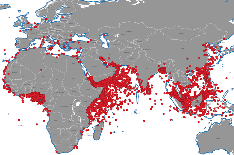
map from west coast of Africa to east coast of Asia with red dots denoting pirate attacks along coasts
Each dot represents a maritime pirate attack that happened between 1995 and 2023.
Brandon Prins

21st-century pirates

The 2013 Hollywood movie “Captain Phillips,” starring Tom Hanks, drew attention back to real-world pirates and piracy. The movie was based on a real-life 2009 attack by Somali pirates on a ship named the MV Maersk Alabama, which was carrying food to Kenya. The 500-foot-long vessel and its crew were rescued by the U.S. Navy.

To better understand 21st-century piracy, my research team compiled data on all pirate attacks from 1995 to the present day. We found three main piracy hot spots: the Gulf of Aden near Somalia, the Strait of Malacca in Southeast Asia and the Gulf of Guinea off the coast of West Africa. All three locations experience the conditions that attract pirates: ship traffic, valuable cargo and weak governments.

Why become a pirate?

People become pirates for many reasons, not the least of which is to escape poverty and enslavement. Others just want adventure and to travel the world. These are the same motivations that drove commerce raiding in the ancient world, during the golden age of piracy, and even today.

While we may never know the first pirate, just like we will never know the very first thief, historical evidence shows that sea-raiding has been around since the very first boats traversed the world’s waterways. Despite efforts to end piracy, my research shows that the conditions that produce ship looting remain and will likely always exist.


Hello, curious kids! Do you have a question you’d like an expert to answer? Ask an adult to send your question to CuriousKidsUS@theconversation.com. Please tell us your name, age and the city where you live.

And since curiosity has no age limit – adults, let us know what you’re wondering, too. We won’t be able to answer every question, but we will do our best.

The Conversation

Brandon Prins received funding from the U.S. Department of Defense, Office of Naval Research, through the Minerva Initiative, awards #N00014-21-1-2030 and #N00014-14-1-0050.

ref. Who was the first pirate? – https://theconversation.com/who-was-the-first-pirate-256314

Zohran Mamdani’s last name reflects centuries of intercontinental trade, migration and cultural exchange

Source: The Conversation – USA (3) – By Iqbal Akhtar, Associate Professor of Religious Studies, Florida International University

Zohran Mamdani takes photos with union members during a campaign rally at the Hotel and Gaming Trades Council headquarters in New York on July 2, 2025. AP Photo/Richard Drew

When Zohran Mamdani announced his candidacy for mayor of New York City, political observers noted his progressive platform and legislative record. But understanding the Democratic candidate’s background requires examining the rich cultural tapestry woven into his very surname: Mamdani.

He takes the name from his father, Mahmood Mamdani, a prominent academic who was raised in Uganda and whose work focuses on postcolonial Uganda. I studied the history of the Khoja community for my doctoral work and have helped develop Khoja studies as an academic discipline. The Mamdani surname tells a story of migration, resilience and community-building that spans centuries and continents.

The Khoja history

Mamdanis in Uganda belong to the Khoja community, a South Asian Muslim merchant caste, that shaped economic development across the western Indian Ocean for centuries.

The name originates from greater Sindh, a region in South Asia that today includes southeastern Pakistan and Kachchh in western India.

Its etymology is twofold. Mām is an honorific title in Kachchhi and Gujarati languages, meaning kindness, courage and pride. Māmadō is a local version of the name Muhammad that often appeared in surnames in Hindu castes that converted to Islam, such as the Memons.

The Khoja were categorized by the British in the early 19th century as “Hindoo Mussalman” because their traditions spanned both religions.

Over time, the Khoja came to be identified only as Muslim and then primarily as Shiite Muslim. Today, the majority of Khoja are Ismaili: a branch of Shiite Islam that follows the Aga Khan as their living imam.

The Mamdani family, however, is part of the Twelver community of Khoja, whose Twelfth Imam is believed to be hidden from the world and only emerges in times of crisis. Twelvers believe he will help usher in an age of peace during end times.

Around the late 18th century, the Khoja helped export textiles, manufactured goods, spices and gems from the Indian subcontinent to Arabia and East Africa. Through this Western Indian Ocean trading network, they imported timber, ivory, minerals and cloves, among other goods.

Khoja family firms were built on kinship networks and trust. They built networks of shops, communal housing and warehouses, and extended credit for thousands of miles, from Zanzibar in Tanzania to Bombay – now Mumbai – on the western coast of India.

Cousins and brothers would send money and goods across the ocean with only a letter. The precarious nature of trade in this period meant that families also served as insurance for each other. In times of wealth, it was shared; in times of disaster, help was available.

Khoja contributions in Africa

The Khoja became instrumental in building the commercial infrastructure of eastern, central and southern Africa. But the Khoja contribution to the development of Africa extended far beyond trade.

In the absence of colonial investment in public infrastructure, they helped build institutions that formed the foundation of the modern nation-states that emerged after colonization. The institutions both facilitated trade and established permanent communities.

For example, the first dispensary and public school in Zanzibar were constructed by a Khoja magnate, Tharia Topan, who made his wealth through the ivory and clove trades. Topan eventually became so prominent that he was knighted by Queen Victoria in 1890 for his service to the British Empire in helping to end slavery in East Africa.

The Khoja community continues to invest in East Africa. The most famous example is the Aga Khan Development Network, whose hospitals and schools operate in 30 countries. In places such as Kenya, Uganda and Tanzania, they are considered the best.

Khoja in Uganda

Like in other parts of Africa, the Khoja settled in Uganda as a liaison business community to develop a market to serve both African and European needs. The linguistic and cultural knowledge, developed over centuries, helped facilitate business despite the challenges of colonization.

A Black man in a suit walking with a woman and another dressed in traditional African attire.
Ugandan President Idi Amin and his wife, Sarah, in Rome on Sept. 10, 1975.
AP Photo

However, in 1972, Ugandan dictator Idi Amin expelled all Asians – approximately 80,000 – forcing families like the Mamdanis into exile. These included indentured laborers, who were brought in to help build the railroad and farm during the British colonial period, and free traders, like the Mamdani family.

Amin saw them all as the same and famously said: “Asians came to Uganda to build the railway. The railway is finished. They must leave now.”

The experience was a bitter one. Families lost everything, and many left with only the clothes on their backs.

Mahmood Mamdani, who came from a Khoja merchant family, was 26 when he was exiled. Yet, unlike most Ugandan Asians, he chose to go back. At Makerere University in Kampala, Uganda’s capital, Mamdani set up the Institute for Social Research, which helped to provide rigorous social science training to Ugandan researchers trying to improve their society.

While the earlier generations of the Khoja tended to choose business or adjacent professions, such as accounting, the subsequent generations – particularly those educated in the West – embraced the knowledge economy as professionals, academics and nonprofit leaders.

Several of Mahmood Mamdani’s generation of Khoja academics conducted path-breaking work on Afro-Asian solidarity – a way of thinking about the world beyond colonial categories, such as the category of religion as a separate domain from the secular. These scholars, such as Tanzania’s Issa Shivji and Abdul Sheriff, worked on creating solidarity among the newly independent states of the Global South.

Mahmood Mamdani is known for his influential post-9/11 academic work, “Good Muslim, Bad Muslim,” which examined how Muslim identities are stereotyped. He argued that these identities are complex and varied, shaped by accumulated history and present experiences.

Interfaith identity

The Khoja community – known globally as the Khoja Shia Ithnasheri Muslim Community – has developed strong transnational connections. Today, they are concentrated in the United Kingdom, Canada, United States and France. However, Khoja can be found in almost any country in the world. In 2013, I met members of the community in Hong Kong.

The Khoja community plays an important role in interfaith dialogue and global development initiatives. A prominent Ismaili Khoja, Eboo Patel, the founder of Interfaith America, has dedicated his life to pluralism and mutual understanding through building up civil society.

Zohran Mamdani’s mother, acclaimed filmmaker Mira Nair, is Hindu by birth. This interfaith marriage exemplifies the flexibility, diversity and tolerance of Khoja Islam, which has historically navigated between Hindu and Islamic traditions.

Whether Mamdani’s policies prove practical remains to be seen, but his background offers something valuable: a deep understanding of how communities build resilience across generations and geographies.

The Conversation

Iqbal Akhtar does not work for, consult, own shares in or receive funding from any company or organization that would benefit from this article, and has disclosed no relevant affiliations beyond their academic appointment.

ref. Zohran Mamdani’s last name reflects centuries of intercontinental trade, migration and cultural exchange – https://theconversation.com/zohran-mamdanis-last-name-reflects-centuries-of-intercontinental-trade-migration-and-cultural-exchange-259967

Why Texas Hill Country, where a devastating flood killed more than 130 people, is one of the deadliest places in the US for flash flooding

Source: The Conversation – USA (2) – By Hatim Sharif, Professor of Civil and Environmental Engineering, The University of Texas at San Antonio

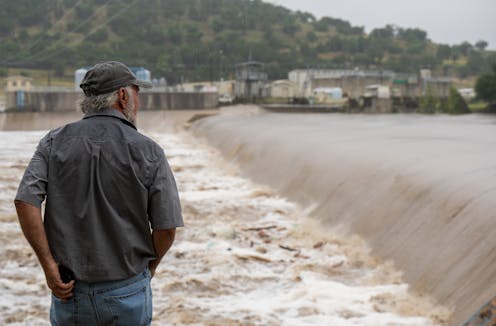
A Kerrville, Texas, resident watches the flooded Guadalupe River on July 4, 2025. Eric Vryn/Getty Images

Texas Hill Country is known for its landscapes, where shallow rivers wind among hills and through rugged valleys. That geography also makes it one of the deadliest places in the U.S. for flash flooding.

In the early hours of July 4, 2025, a flash flood swept through an area of Hill Country dotted with summer camps and small towns about 70 miles northwest of San Antonio. More than 130 people died in the flooding. The majority of them were in Kerr County, including more than two dozen girls and counselors at one summer camp, Camp Mystic. Dozens more people were still unaccounted for a week later.

The flooding began with a heavy downpour, with more than 10 inches of rain in some areas, that sent water sheeting off the hillsides and into creeks. The creeks poured into the Guadalupe River.

A river gauge at Hunt, Texas, near Camp Mystic, showed how quickly the river flooded: Around 3 a.m. on July 4, the Guadalupe River was rising about 1 foot every 5 minutes at the gauge, National Weather Service data shows. By 4:30 a.m., it had risen more than 20 feet. As the water moved downstream, it reached Kerrville, where the river rose even faster.

Flood expert Hatim Sharif, a hydrologist and civil engineer at the University of Texas at San Antonio, explains what makes this part of the country, known as Flash Flood Alley, so dangerous.

What makes Hill Country so prone to flooding?

Texas as a whole leads the nation in flood deaths, and by a wide margin. A colleague and I analyzed data from 1959 to 2019 and found 1,069 people had died in flooding in Texas over those six decades. The next highest total was in Louisiana, with 693.

Many of those flood deaths have been in Hill County. It’s part of an area known as Flash Flood Alley, a crescent of land that curves from near Dallas down to San Antonio and then westward.

The hills are steep, and the water moves quickly when it floods. This is a semi-arid area with soils that don’t soak up much water, so the water sheets off quickly and the shallow creeks can rise fast.

When those creeks converge on a river, they can create a surge of water that wipes out homes and washes away cars and, unfortunately, anyone in its path.

Hill Country has seen some devastating flash floods. In 1987, heavy rain in western Kerr County quickly flooded the Guadalupe River, triggering a flash flood similar to the one in 2025. Ten teenagers being evacuated from a camp died in the rushing water.

San Antonio, at the eastern edge of Hill Country, was hit with a flash flood on June 12, 2025, that killed 13 people whose cars were swept away by high water from a fast-flooding creek near an interstate ramp in the early morning.

Why does the region get such strong downpours?

One reason Hill Country gets powerful downpours is the Balcones Escarpment.

The escarpment is a line of cliffs and steep hills created by a geologic fault. When warm air from the Gulf rushes up the escarpment, it condenses and can dump a lot of moisture. That water flows down the hills quickly, from many different directions, filling streams and rivers below.

As temperature rise, the warmer atmosphere can hold more moisture, increasing the downpour and flood risk.

A tour of the Guadalupe River and its flood risk.

The same effect can contribute to flash flooding in San Antonio, where the large amount of paved land and lack of updated drainage to control runoff adds to the risk.

What can be done to improve flash flood safety?

First, it’s important for people to understand why flash flooding happens and just how fast the water can rise and flow. In many arid areas, dry or shallow creeks can quickly fill up with fast-moving water and become deadly. So people should be aware of the risks and pay attention to the weather.

Improving flood forecasting, with more detailed models of the physics and water velocity at different locations, can also help.

Probabilistic forecasting, for example, can provide a range of rainfall scenarios, enabling authorities to prepare for worst-case scenarios. A scientific framework linking rainfall forecasts to the local impacts, such as streamflow, flood depth and water velocity, could also help decision-makers implement timely evacuations or road closures.

Education is particularly essential for drivers. One to two feet of moving water can wash away a car. People may think their trucks and SUVs can go through anything, but fast-moving water can flip a truck and carry it away.

Officials can also do more to barricade roads when the flood risk is high to prevent people from driving into harm’s way. We found that 58% of the flood deaths in Texas over the past six decades involved vehicles. The storm on June 12 in San Antonio was an example. It was early morning, and drivers had poor visibility. The cars were hit by fast-rising floodwater from an adjacent creek.

This article, originally published July 5, 2025, has been updated with the death toll rising.

The Conversation

Hatim Sharif does not work for, consult, own shares in or receive funding from any company or organization that would benefit from this article, and has disclosed no relevant affiliations beyond their academic appointment.

ref. Why Texas Hill Country, where a devastating flood killed more than 130 people, is one of the deadliest places in the US for flash flooding – https://theconversation.com/why-texas-hill-country-where-a-devastating-flood-killed-more-than-130-people-is-one-of-the-deadliest-places-in-the-us-for-flash-flooding-260555

When disasters fall out of the public eye, survivors continue to suffer – a rehabilitation professional explains how sustained mental health support is critical to recovery

Source: The Conversation – USA (3) – By Lee Ann Rawlins Williams, Clinical Assistant Professor of Education, Health and Behavior Studies, University of North Dakota

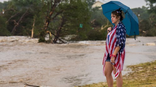
In Kerrville, Texas, Leighton Sterling watches the rushing floodwaters along the Guadalupe River on July 4, 2025. Eric Vryn via Getty Images News

The devastating losses from the historic flooding in Texas Hill Country on July 4, 2025, are still coming into grim focus, with 121 deaths confirmed and more than 100 still missing as of July 10.

As emergency responders focus on clearing debris and searching for victims, a less visible and slower disaster has been unfolding: the need for ongoing mental health support long after headlines fade.

This phase is no less critical than restoring power or rebuilding bridges. Disasters destabilize emotional well-being, leaving distress, prolonged recovery and long-term impacts in their wake long after the event is over.

Without sustained emotional support, people and communities face heightened risks of prolonged trauma and stalled recovery.

As an educator and practitioner focused on disability and rehabilitation, I explore the intersection of disaster recovery and the impact of disasters on mental health. Both my research and that of others underscore the vital importance of support systems that not only help people cope in the immediate aftermath of a disaster but also facilitate long-term healing over the months and years that follow – especially for vulnerable populations like children, older adults and people with disabilities.

The emotional toll of disasters

Natural disasters disrupt routines, displace families and challenge people’s sense of control and security. In the immediate aftermath, survivors often experience shock, grief, anxiety and sleep disturbances. Often these symptoms may evolve into chronic stress, depression, post-traumatic stress disorder or a combination of these conditions.

A 2022 study found that Texans who experienced two or more disasters within a five-year span had significantly poorer mental health, as reflected by lower scores on standardized psychological assessments, which highlights the cumulative toll repeated disasters can have on mental well-being.

After Hurricane Katrina ravaged New Orleans in 2005, nearly a third of survivors continued to experience poor mental health years later.

And reports following Hurricane Maria in Puerto Rico in 2017 revealed surging rates of anxiety, depression and suicidal thoughts, especially in areas where services remained unavailable for extended periods of time.

There are actionable ways to make a difference in the recovery process.

Strained recovery systems

Disaster response understandably focuses on immediate needs like rescue operations, providing post-disaster housing and repairing damaged infrastructure. In addition, short-term mental health supports such as mobile health clinics are often provided in the immediate aftermath of a disaster.

However, although emergency services are deployed quickly after a disaster, long-term mental health support is often delayed or under-resourced, leaving many people without continued care during the recovery period, especially in remote or rural communities, exposing deep structural gaps in how recovery systems are designed.

One year after Hurricane Harvey devastated parts of Texas in 2017, more than 90% of Gulf Coast residents reported ongoing stress related to housing instability, financial hardship or displacement. Yet less than 10% of people stated that they or someone in their household had used mental health services following the disaster.

Hurricane Helene in 2024 similarly tested the resilience of rural mental health networks in western North Carolina. The storm damaged roads and bridges, schools and even local clinics.

This prompted a news organization, North Carolina Health News, to warn of rising “trauma, stress and isolation” among residents as providers scrambled to offer free counseling despite legal barriers stemming from licensing requirements to provide counseling across state borders. State health officials activated community crisis centers and helplines, while mobile mental health teams were dispatched from Tennessee to help those impacted by the disaster. However, state representatives stressed that without long-term investment, these critical supports risk being one-off responses.

These events serve as a powerful reminder that while roads and buildings can often be restored quickly, emotional recovery is a slower, more complex process. Truly rebuilding requires treating mental health with the same urgency as physical infrastructure. This requires investing in strong mental health recovery systems, supporting local clinics, sustaining provider networks and integrating emotional care into recovery plans from the start.

Surrounded by community members and volunteers, an emotionally distraught woman speaks to the governor of Texas.
In Hunt, Texas, Gov. Greg Abbott speaks to volunteers and community members during a news conference on July 8, 2025.
Brandon Bell via Getty Images News

Finding mental health support following a disaster

Lessons learned from previous disasters and an abundance of research show how sustained mental health supports can help people recover and build resilience.

These six lessons are particularly helpful for finding needed mental health support following a disaster:

  • If you’re feeling overwhelmed after a disaster, you’re not alone, and help is available. Free and confidential support is offered through resources like the Disaster Distress Helpline (1-800-985-5990 or text TalkWithUs to 66746), which connects you to trained counselors 24/7.

  • Many communities offer local mental health crisis lines or walk-in centers that remain active well after the disaster passes. Check your county or state health department’s website for updated listings and information.

  • Even if physical offices are closed, many clinics now offer virtual counseling or can connect you with therapists and medication refills remotely. If you’ve seen someone before, ask if they’re still available by phone or video.

  • After major disasters, states often deploy mobile health clinics that include mental health services to shelters, churches or schools. These temporary services are free and open to the public.

  • If someone you care about is struggling, help them connect with resources in the community. Share hotline numbers, offer to help make an appointment or just let them know it’s OK to ask for support. Many people don’t realize that help is available, or they think it’s only for more “serious” problems. It’s not.

  • Mental health support doesn’t always arrive right away. Keep an eye on local news, school updates or health department alerts for new services that may become available in the weeks or months after a disaster.

Disasters don’t just damage buildings; they disrupt lives in lasting ways.

While emotional recovery takes time, support is available. Staying informed and sharing resources with others can help ensure that the road to recovery isn’t traveled alone.

The Conversation

Lee Ann Rawlins Williams does not work for, consult, own shares in or receive funding from any company or organization that would benefit from this article, and has disclosed no relevant affiliations beyond their academic appointment.

ref. When disasters fall out of the public eye, survivors continue to suffer – a rehabilitation professional explains how sustained mental health support is critical to recovery – https://theconversation.com/when-disasters-fall-out-of-the-public-eye-survivors-continue-to-suffer-a-rehabilitation-professional-explains-how-sustained-mental-health-support-is-critical-to-recovery-260781

Disasters don’t disappear when the storm ends – cascading hazards, from landslides to floods, are upending risk models

Source: The Conversation – USA (2) – By Brian J. Yanites, Associate Professor of Earth and Atmospheric Science. Robert Shrock Professor of Surficial and Sedimentary Geology, Indiana University

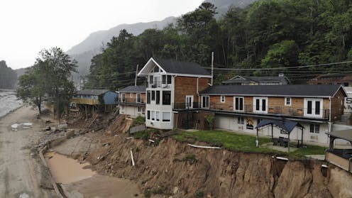
The Carter Lodge hangs precariously over the flood-scoured bank of the Broad River in Chimney Rock Village, N.C., on May 13, 2025, eight months after Hurricane Helene. AP Photo/Allen G. Breed

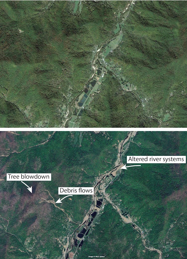
Hurricane Helene lasted only a few days in September 2024, but it altered the landscape of the Southeastern U.S. in profound ways that will affect the hazards local residents face far into the future.

Mudslides buried roads and reshaped river channels. Uprooted trees left soil on hillslopes exposed to the elements. Sediment that washed into rivers changed how water flows through the landscape, leaving some areas more prone to flooding and erosion.

Helene was a powerful reminder that natural hazards don’t disappear when the skies clear – they evolve.

These transformations are part of what scientists call cascading hazards. They occur when one natural event alters the landscape in ways that lead to future hazards. A landslide triggered by a storm might clog a river, leading to downstream flooding months or years later. A wildfire can alter the soil and vegetation, setting the stage for debris flows with the next rainstorm.

Two satellite maps of the same location. One shows changes to the river, loss of trees and landslides.
Satellite images before (top) and after Hurricane Helene (bottom) show how the storm altered landscape near Pensacola, N.C., in the Blue Ridge Mountains.
Google Earth, CC BY

I study these disasters as a geomorphologist. In a new paper in the journal Science, I and a team of scientists from 18 universities and the U.S. Geological Survey explain why hazard models – used to help communities prepare for disasters – can’t just rely on the past. Instead, they need to be nimble enough to forecast how hazards evolve in real time.

The science behind cascading hazards

Cascading hazards aren’t random. They emerge from physical processes that operate continuously across the landscape – sediment movement, weathering, erosion. Together, the atmosphere, biosphere and the earth are constantly reshaping the conditions that cause natural disasters.

For instance, earthquakes fracture rock and shake loose soil. Even if landslides don’t occur during the quake itself, the ground may be weakened, leaving it primed for failure during later rainstorms.

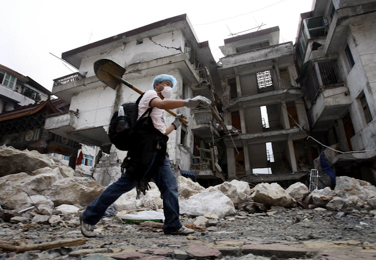
That’s exactly what happened after the 2008 earthquake in Sichuan Province, China, which led to a surge in debris flows long after the initial seismic event.

A volunteer carrying a shovel over his shoulder walks past boulders and a severely damaged building.
A strong aftershock after a 7.8 magnitude earthquake in Sichuan province, China, in May 2008 triggered more landslides in central China.
AP Photo/Andy Wong

Earth’s surface retains a “memory” of these events. Sediment disturbed in an earthquake, wildfire or severe storm will move downslope over years or even decades, reshaping the landscape as it goes.

The 1950 Assam earthquake in India is a striking example: It triggered thousands of landslides. The sediment from these landslides gradually moved through the river system, eventually causing flooding and changing river channels in Bangladesh some 20 years later.

An intensifying threat in a changing world

These risks present challenges for everything from emergency planning to home insurance. After repeated wildfire-mudslide combinations in California, some insurers pulled out of the state entirely, citing mounting risks and rising costs among the reasons.

Cascading hazards are not new, but their impact is intensifying.

Climate change is increasing the frequency and severity of wildfires, storms and extreme rainfall. At the same time, urban development continues to expand into steep, hazard-prone terrain, exposing more people and infrastructure to evolving risks.

The rising risk of interconnected climate disasters like these is overwhelming systems built for isolated events.

Yet climate change is only part of the equation. Earth processes – such as earthquakes and volcanic eruptions – also trigger cascading hazards, often with long-lasting effects.

Mount St. Helens is a powerful example: More than four decades after its eruption in 1980, the U.S. Army Corps of Engineers continues to manage ash and sediment from the eruption to keep it from filling river channels in ways that could increase the flood risk in downstream communities.

Rethinking risk and building resilience

Traditionally, insurance companies and disaster managers have estimated hazard risk by looking at past events.

But when the landscape has changed, the past may no longer be a reliable guide to the future. To address this, computer models based on the physics of how these events work are needed to help forecast hazard evolution in real time, much like weather models update with new atmospheric data.

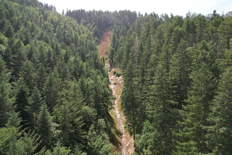
An aerial view of a river with evidence of a landslide. Broken trees look like toothpicks scattered about, and the river flow is partially blocked.
A March 2024 landslide in the Oregon Coast Range wiped out trees in its path.
Brian Yanites, June 2025
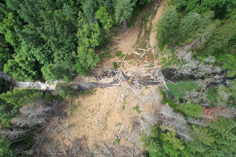
An aerial view of a river with evidence of a landslide. Broken trees look like toothpicks scattered about, and the river flow is partially blocked.
A drone image of the same March 2024 landslide in the Oregon Coast Range shows where it temporarily dammed the river below.
Brian Yanites, June 2025

Thanks to advances in Earth observation technology, such as satellite imagery, drone and lidar, which is similar to radar but uses light, scientists can now track how hillslopes, rivers and vegetation change after disasters. These observations can feed into geomorphic models that simulate how loosened sediment moves and where hazards are likely to emerge next.

Researchers are already coupling weather forecasts with post-wildfire debris flow models. Other models simulate how sediment pulses travel through river networks.

Cascading hazards reveal that Earth’s surface is not a passive backdrop, but an active, evolving system. Each event reshapes the stage for the next.

Understanding these connections is critical for building resilience so communities can withstand future storms, earthquakes and the problems created by debris flows. Better forecasts can inform building codes, guide infrastructure design and improve how risk is priced and managed. They can help communities anticipate long-term threats and adapt before the next disaster strikes.

Most importantly, they challenge everyone to think beyond the immediate aftermath of a disaster – and to recognize the slow, quiet transformations that build toward the next.

The Conversation

Brian J. Yanites receives funding from the National Science Foundation.

ref. Disasters don’t disappear when the storm ends – cascading hazards, from landslides to floods, are upending risk models – https://theconversation.com/disasters-dont-disappear-when-the-storm-ends-cascading-hazards-from-landslides-to-floods-are-upending-risk-models-259502

A wildfire’s legacy can haunt rivers for years, putting drinking water at risk

Source: The Conversation – USA (2) – By Ben Livneh, Associate Professor of Hydrology, University of Colorado Boulder

Burned ground can become hydrophobic and almost waxlike, allowing rainfall to quickly wash contaminants downslope. Carli Brucker

A wildfire rages across a forested mountainside. The smoke billows and the flames rise. An aircraft drops vibrant red flame retardant. It’s a dramatic, often dangerous scene. But the threat is only just beginning for downstream communtiies and the water they rely on.

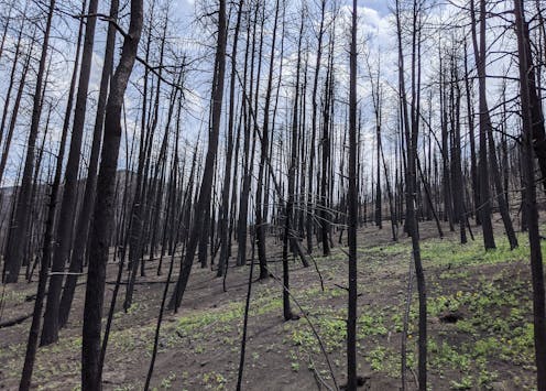
After the smoke clears, the soil, which was once nestled beneath a canopy of trees and a spongy layer of leaves, is now exposed. Often, that soil is charred and sterile, with the heat making the ground almost water-repellent, like a freshly waxed car.

When the first rain arrives, the water rushes downhill. It carries with it a slurry of ash, soil and contaminants from the burned landscape. This torrent flows directly into streams and then rivers that provide drinking water for communities downstream.

As a new research paper my colleagues and I just published shows, this isn’t a short-term problem. The ghost of the fire can haunt these waterways for years.

Scientists explain how wildfires can contaminate water supplies and the ways they measure the effects, summarized in their 2024 publication. University of Colorado-Boulder.

This matters because forested watersheds are the primary water source for nearly two-thirds of municipalities in the United States. As wildfires in the western U.S. become larger and more frequent, the long-term security and safety of water supplies for downstream communities is increasingly at risk.

Charting the long tail of wildfire pollution

Scientists have long known that wildfires can affect water quality, but two key questions remained: Exactly how bad is the impact? And how long does it last?

To find out, my colleagues and I led a study, coordinated by engineer Carli Brucker. We undertook one of the most extensive analyses of post-wildfire water quality to date. The results were published June 23, 2025, in the journal Nature Communications Earth & Environment.

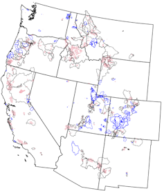
We gathered decades of water quality data from 245 burned watersheds across the western U.S. and compared them to nearly 300 similar, unburned watersheds.

A map of watersheds in the western U.S.
A map of the basins studied shows the outlines of fires in red and burned basins in black. The blue basins did not burn and were used for comparisons.
Carli Brucker, et al., 2025, Nature Communications Earth & Environment

By creating a computer model for each basin that accounted for its normal water quality variability, based on factors such as rainfall and temperature, we were able to isolate the impact of the wildfire. This allowed us to see how much the water quality deviated after the fire, year after year.

The results were stark. In the first year after a fire, the concentrations of some contaminants skyrocketed. We found that levels of sediment and turbidity – the cloudiness of the water – were 19 to 286 times higher than prefire levels. That much sediment can clog filters at water treatment plants and require expensive treatment and maintenance. Think of trying to use a coffee filter with muddy water – the water just won’t flow through.

Concentrations of organic carbon, nitrogen and phosphorus were three to 103 times greater in the burned basins. These dissolved remnants of burned plants and soil are particularly problematic. When they mix with the chlorine used to disinfect drinking water, they can form harmful chemicals called disinfection byproducts, some of which are linked to cancer.

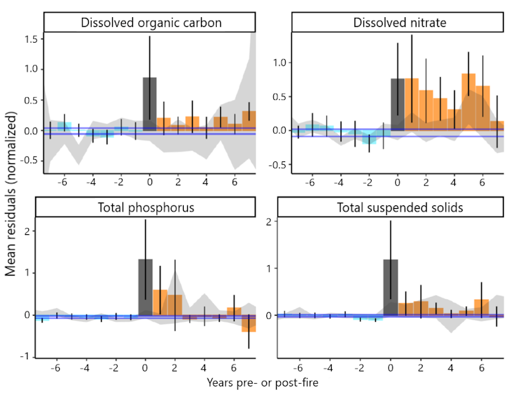
More surprisingly, we found the impacts to be really persistent. While the most dramatic spikes in phosphorous, nitrate, organic carbon and sediment generally occurred in the first one to three years, some contaminants lingered for much longer.

Charts show how contaminants lingered in water supplies for years after wildfires.
Contaminants including phosphorus, organic carbon and nitrates lingered in water supplies for years after wildfires. The charts show the average among all burned basins eight years before fires (light blue) and all burned basins after fires (orange). The gray bars show levels in the year immediately after the fire. The horizontal purple line shows levels that would be expected without a fire, based on the prefire years.
Carli Brucker, et al., 2025, Nature Communications Earth & Environment

We saw significantly elevated levels of nitrogen and sediment for up to eight years following a fire. Nitrogen and phosphorus act like fertilizer for algae. A surge of these nutrients can trigger algal blooms in reservoirs, which can produce toxins and create foul odors.

This extended timeline suggests that wildfires are fundamentally altering the landscape in ways that take a long time to heal. In our previous laboratory-based research, including a 2024 study, we simulated this process by burning soil and vegetation and then running water over them.

A blackened mountain slope where all of the trees have burned.
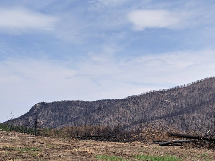
After mountain slopes burn, the rain that falls on them washes ash, charred soil and debris downstream.
Carli Brucker

The stuff that leaches out is a cocktail of carbon, nutrients and other compounds that can exacerbate flood risks and degrade water quality in ways that require more expensive treatment at water treatment facilities. In extreme cases, the water quality may be so poor that communities can’t withdraw river water at all, and that can create water shortages.

After the Buffalo Creek Fire in 1996 and then the Hayman Fire in 2002, Denver’s water utility spent more than US$27 million over several years to treat the water, remove more than 1 million cubic yards of sediment and debris from a reservoir, and fix infrastructure. State Forest Service crews planted thousands of trees to help restore the surrounding forest’s water filtering capabilities.

A growing challenge for water treatment

This long-lasting impact poses a major challenge for water treatment plants that make river water safe to drink. Our study highlights that utilities can’t just plan for a few bad months after a fire. They need to be prepared for potentially eight or more years of degraded water quality.

We also found that where a fire burns matters. Watersheds with thicker forests or more urban areas that burned tended to have even worse water quality after a fire.

Since many municipalities draw water from more than one source, understanding which watersheds are likely to have the largest water quality problems after fires can help communities locate the most vulnerable parts of their water supply systems.

As temperatures rise and more people move into wildland areas in the American West, the risk of wildfires increases, and it is becoming clear that preparing for longer-term consequences is crucial. The health of forests and our communities’ drinking water are inseparably linked, with wildfires casting a shadow that lasts long after the smoke clears.

The Conversation

Ben Livneh receives funding from the Western Water Assessment NOAA grant #NA21OAR4310309, ‘Western Water Assessment: Building Resilience to Compound Hazards in the Inter-Mountain West’.

ref. A wildfire’s legacy can haunt rivers for years, putting drinking water at risk – https://theconversation.com/a-wildfires-legacy-can-haunt-rivers-for-years-putting-drinking-water-at-risk-259118

FEMA’s flood maps often miss dangerous flash flood risks, leaving homeowners unprepared

Source: The Conversation – USA (2) – By Jeremy Porter, Professor of Quantitative Methods in the Social Sciences, City University of New York

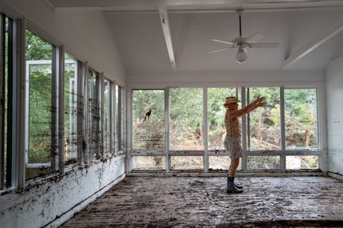
A deadly flash flood on July 4, 2025, swept through Nancy Callery’s childhood home in Hunt, Texas. Brandon Bell/Getty Images

Destructive flash flooding in Texas and other states is raising questions about the nation’s flood maps and their ability to ensure that communities and homeowners can prepare for rising risks.

The U.S. Federal Emergency Management Agency’s flood maps are intended to be the nation’s primary tool for identifying flood risks.

Originally developed in the 1970s to support the National Flood Insurance Program, these maps, known as Flood Insurance Rate Maps, or FIRMs, are used to determine where flood insurance is required for federally backed mortgages, to inform local building codes and land-use decisions, and to guide flood plain management strategies.

A flood risk map.
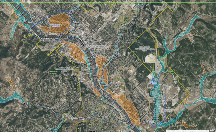
A federal flood map of Kerrville, Texas, with the Guadalupe River winding through the middle in purple, shows areas considered to have a 1% annual chance of flooding in blue and a 0.2% annual chance of flooding in tan. During a flash flood on July 4, 2025, the river rose more than 30 feet at Kerrville.
FEMA

In theory, the maps enable homeowners, businesses and local officials to understand their flood risk and take appropriate steps to prepare and mitigate potential losses.

But while FEMA has improved the accuracy and accessibility of the maps over time with better data, digital tools and community input, the maps still don’t capture everything – including the changing climate. There are areas of the country that flood, some regularly, that don’t show up on the maps as at risk.

I study flood-risk mapping as a university-based researcher and at First Street, an organization created to quantify and communicate climate risk. In a 2023 assessment using newly modeled flood zones with climate-adjusted precipitation records, we found that more than twice as many properties across the country were at risk of a 100-year flood than the FEMA maps identified.

Even in places where the FEMA maps identified a flood risk, we found that the federal mapping process, its overreliance on historical data, and political influence over the updating of maps can lead to maps that don’t fully represent an area’s risk.

What FEMA flood maps miss

FEMA’s maps are essential tools for identifying flood risks, but they have significant gaps that limit their effectiveness.

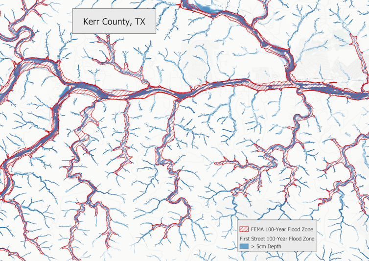
One major limitation is that they don’t consider flooding driven by intense bursts of rain. The maps primarily focus on river channels and coastal flooding, largely excluding the risk of flash flooding, particularly along smaller waterways such as streams, creeks and tributaries.

This limitation has become more important in recent years due to climate change. Rising global temperatures can result in more frequent extreme downpours, leaving more areas vulnerable to flooding, yet unmapped by FEMA.

A map overlay shows how two 100-year flood maps compare. First Street shows many more streams.
A map of a section of Kerr County, Texas, where a deadly flood struck on July 4, 2025, compares the FEMA flood map’s 100-year flood zone (red) to First Street’s more detailed 100-year flood zone (blue). The more detailed map includes flash flood risks along smaller creeks and streams.
Jeremy Porter

For example, when flooding from Hurricane Helene hit unmapped areas around Asheville, North Carolina, in 2024, it caused a huge amount of uninsured damage to properties.

Even in areas that are mapped, like the Camp Mystic site in Kerr County, Texas, that was hit by a deadly flash flood on July 4, 2025, the maps may underestimate their risk because of a reliance on historic data and outdated risk assessments.

Political influence can fuel long delays

Additionally, FEMA’s mapping process is often shaped by political pressures.

Local governments and developers sometimes fight to avoid high-risk designations to avoid insurance mandates or restrictions on development, leading to maps that may understate actual risks and leave residents unaware of their true exposure.

An example is New York City’s appeal of a 2015 FEMA Flood Insurance Rate Maps update. The delay in resolving the city’s concerns has left it with maps that are roughly 20 years old, and the current mapping project is tied up in legal red tape.

On average, it takes five to seven years to develop and implement a new FEMA Flood Insurance Rate Map. As a result, many maps across the U.S. are significantly out of date, often failing to reflect current land use, urban development or evolving flood risks from extreme weather.

This delay directly affects building codes and infrastructure planning, as local governments rely on these maps to guide construction standards, development approvals and flood mitigation projects. Ultimately, outdated maps can lead to underestimating flood risks and allowing vulnerable structures to be built in areas that face growing flood threats.

How technology advances can help

New advances in satellite imaging, rainfall modeling and high-resolution lidar, which is similar to radar but uses light, make it possible to create faster, more accurate flood maps that capture risks from extreme rainfall and flash flooding.

However, fully integrating these tools requires significant federal investment. Congress controls FEMA’s mapping budget and sets the legal framework for how maps are created. For years, updating the flood maps has been an unpopular topic among many publicly elected officials, because new flood designations can trigger stricter building codes, higher insurance costs and development restrictions.

A map of Houston showing flooding extending much farther inland.
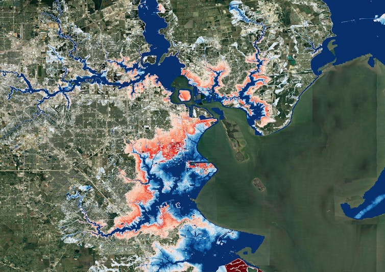
A map of Houston, produced for a 2022 study by researchers at universities and First Street, shows flood risk changing over the next 30 years as climate change worsens. Blue areas are today’s 100-year flood-risk zones. The red areas reflect the same zones in 2050.
Oliver Wing et al., 2022

In recent years, the rise of climate risk analytics models and private flood risk data have allowed the real estate, finance and insurance industries to rely less on FEMA’s maps. These new models incorporate forward-looking climate data, including projections of extreme rainfall, sea-level rise and changing storm patterns – factors FEMA’s maps generally exclude.

Real estate portals like Zillow, Redfin, Realtor.com and Homes.com now provide property-level flood risk scores that consider both historical flooding and future climate projections. The models they use identify risks for many properties that FEMA maps don’t, highlighting hidden vulnerabilities in communities across the United States.

Research shows that the availability, and accessibility, of climate data on these sites has started driving property-buying decisions that increasingly take climate change into account.

Implications for the future

As homebuyers understand more about a property’s flood risks, that may shift the desirability of some locations over time. Those shifts will have implications for property valuations, community tax-revenue assessments, population migration patterns and a slew of other considerations.

However, while these may feel like changes being brought on by new data, the risk was already there. What is changing is people’s awareness.

The federal government has an important role to play in ensuring that accurate risk assessments are available to communities and Americans everywhere. As better tools and models evolve for assessing risk evolve, FEMA’s risk maps need to evolve, too.

The Conversation

Jeremy Porter has nothing to disclose.

ref. FEMA’s flood maps often miss dangerous flash flood risks, leaving homeowners unprepared – https://theconversation.com/femas-flood-maps-often-miss-dangerous-flash-flood-risks-leaving-homeowners-unprepared-260990